Download the Hadrian’s Wall Facts & Worksheets
Click the button below to get instant access to these worksheets for use in the classroom or at a home.
Download This Worksheet
This download is exclusively for KidsKonnect Premium members!
To download this worksheet, click the button below to signup (it only takes a minute) and you'll be brought right back to this page to start the download!
Sign Me Up
Edit This Worksheet
Editing resources is available exclusively for KidsKonnect Premium members.
To edit this worksheet, click the button below to signup (it only takes a minute) and you'll be brought right back to this page to start editing!
Sign Up
Download This Sample
This sample is exclusively for KidsKonnect members!
To download this worksheet, click the button below to signup for free (it only takes a minute) and you'll be brought right back to this page to start the download!
Sign Me Up
Table of Contents
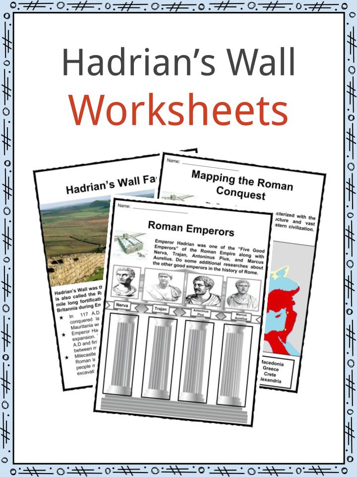
Hadrian’s Wall was the northeastern frontier of the Roman Empire. It is also called the Roman Wall or Vallum Hadriani in Latin. The 80 mile long fortification was built to defend the Roman province of Britannia during Emperor Hadrian’s reign in 122 A.D. See the fact file below for more information on Hadrian’s Wall or alternatively download our comprehensive worksheet pack to utilise within the classroom or home environment.
Hadrian’s Wall Facts
- In 117 A.D Emperor Hadrian ascended to the throne. The conquered lands of Rome including Egypt, Judea, Libya, and Mauritania were all under the state of rebellion.
- Emperor Hadrian secured the Empire’s defense first before further expansion. The defensive fortification started its construction in 122 A.D and finished six years later. The wall was built from east to west between milecastles and forts.
- Milecastles and turrets differed in their designs depending on what Roman legion built it. The construction was divided per legion with people mostly soldiers and migrants who are either member of the excavation or wall construction.
- The walls are classified as narrow and broad walls. Turf Walls in the River Irthing were built in broad walls indicating where the construction began. The turrets and milecastles were wider with full-sized forts for auxiliary troops. Narrow walls can be seen as the walls reached the North Tyne.
- Later on, the Turf Wall was demolished and reconstructed with a stone wall. Allowing the line to go further north.
- The existence of garrisons suggested that elevated platforms served as the soldiers’ walk way to observe the movements of the people. Each fort housed a community with garrison, headquarters, barracks, and civilian settlements.
- After the death of Emperor Hadrian in 138 A.D, his successor Emperor Antoninus Pius abandoned the wall and constructed a new one called the Antonine Wall crossing north. It is referred to as the Central Belt running west-south-west to east-north-east across the isthmus. More forts were built compared to Hadrian’s Wall.
- In 164 A.D, when Marcus Aurelius became the emperor he reoccupied the Hadrian Wall and marked it as the main defensive fortification.
Map of Hadrian’s Wall
- During the 18th century, most of the stone pieces were used for road rebuilding for the military under General Wade. By 1830, John Clayton, a lawyer, put interest in preserving the wall. He started buying lands occupying the walls to prevent the farmers from getting stones from the wall. Clayton soon controlled the parts of Chesters, Housesteads, Vindolanda, and Carrawburgh.
- Clayton was successful in managing some livestock giving him profits used for the restoration of the walls. Clayton Wall was built at the Housesteads. After his death, the estate was passed to his relatives which was later lost to gambling.
- In 1987, the Hadrian’s Wall was declared as one of the World’s Heritage Sites. By 2005, along with some site in Germany, it became a part of the transnational “Frontiers of the Roman Empire.”
- After the excavation of archeologists, 16 forts of the Hadrian Wall were recognized written in Latin and Romano-Celtic names: Segedunum (Wallsend), Pons Aelius (Newcastle upon Tyne), Condercum (Benwell Hill), Vindobata (Rudchester), Hunnum (Halton Chester), Cilurnum (Chesters), Procolita (Carrowburgh), Vercovicium (Housesteads), Aesica (Great Chesters), Magnis (Carnovan), Banna (Birdoswald), Cambolaglanna (Castlesteads), and others.
- Hadrian’s Wall have been recognized in books such of Rudyard Kipling’s “Great Pic Wall”, and George R.R Martin’s “The Wall: A Song of Ice and Fire” dramatised in the series of Game of Thrones.
- Number of films used some parts of the wall. In 1991, Robin Hood: Prince of the Thieves used the location in Sycamore gap. The King Arthur film in 2004 utilized one of the major gates as well as the setting inside the walls. The Last Legion and Doomsday were among the others.
Hadrian’s Wall Worksheets
This bundle contains 11 ready-to-use Hadrian’s Wall Worksheets that are perfect for students who want to learn more about the Roman Empire’s northeastern frontier. Hadrian’s Wall is an 80 mile long wall that was built in 122 AD to protect the province of Britannia.
Download includes the following worksheets
- Hadrian’s Wall Facts
- Emperor Hadrian
- Mapping the Roman Conquest
- Roman Empire Facts
- Roman Emperors
- Build the Wall
- Look for the Forts
- Wall Reconstruction
- World Heritage Sites
- Hadrian’s Wall Comic Strips
- Picture Perfect
Frequently Asked Questions
What is so special about Hadrian’s wall?
Hadrian’s Wall was built by the Roman empire and is one of the most dramatic features in all of northern England. Many parts of it are visible for miles, making it a striking addition to the landscape.
Who destroyed Hadrian’s wall?
The Picts were a problem for the Romans. They almost destroyed Hadrian’s Wall three times. But the Roman soldiers rebuilt it every time. The wall was 250 years old and it protected the edge of the Roman empire against anyone who wanted to harm their land.
What is Hadrian’s wall and why was it built?
To better protect Roman Britain from northern invaders, Emperor Hadrian commissioned the construction of a great wall. In his own words, he wanted to create a barrier between “Romans and barbarians.”
Link/cite this page
If you reference any of the content on this page on your own website, please use the code below to cite this page as the original source.
Link will appear as Hadrian’s Wall Facts & Worksheets: https://kidskonnect.com - KidsKonnect, August 24, 2017
Use With Any Curriculum
These worksheets have been specifically designed for use with any international curriculum. You can use these worksheets as-is, or edit them using Google Slides to make them more specific to your own student ability levels and curriculum standards.