Premium
 Download
Edit
Download
Edit
Download the Benin Facts & Worksheets
Click the button below to get instant access to these worksheets for use in the classroom or at a home.
Download This Worksheet
This download is exclusively for KidsKonnect Premium members!
To download this worksheet, click the button below to signup (it only takes a minute) and you'll be brought right back to this page to start the download!
Sign Me Up
Edit This Worksheet
Editing resources is available exclusively for KidsKonnect Premium members.
To edit this worksheet, click the button below to signup (it only takes a minute) and you'll be brought right back to this page to start editing!
Sign Up
Not ready to purchase a subscription? Click to download the free sample version Download sample
Download This Sample
This sample is exclusively for KidsKonnect members!
To download this worksheet, click the button below to signup for free (it only takes a minute) and you'll be brought right back to this page to start the download!
Sign Me Up
Table of Contents
Benin is one of the countries in Africa with the most stable democracy.
See the fact file below for more information on the Benin or alternatively, you can download our 23-page Benin worksheet pack to utilise within the classroom or home environment.
Key Facts & Information
INTRODUCTION
- Benin is officially known as the Republic of Benin and was formerly known as Dahomey.
- Benin is a country located in West Africa.
- Benin is bordered to the west by Togo, to the east by Nigeria, to the northwest by Burkina Faso, and to the northeast by Niger.
- From Dahomey, the country’s name was changed to Republic of Benin on November 30, 1975.
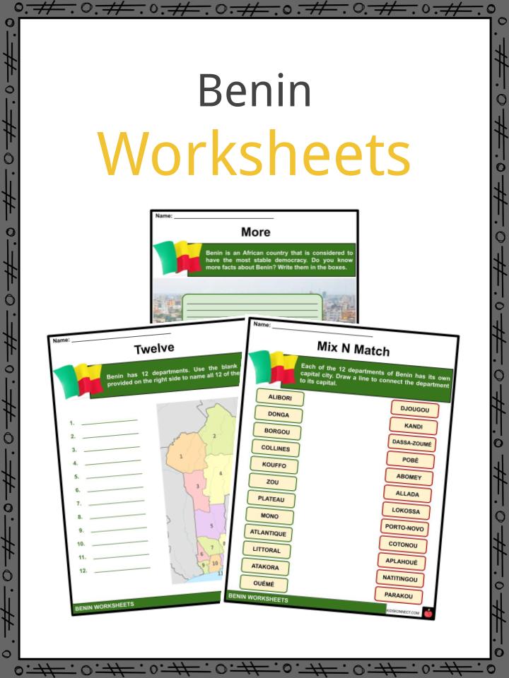
ADMINISTRATIVE REGIONS
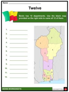
- Benin is divided into 12 departments.
- Each department has its own capital.
- The 12 departments are further subdivided into 77 communes.
- The communes are then further divided into arrondissements and then into villages or city districts.
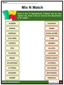
- Below is the department-capital match list:
- Atakora – Natitingou
- Alibori – Kandi
- Donga – Djougou
- Borgou – Parakou
- Collines – Dassa-Zoumé
- Kouffo – Aplahoué
- Zou – Abomey
- Plateau – Pobè
- Mono – Lokossa
- Atlantique – Allada
- Littoral – Cotonou
- Ouémé – Porto-Novo
- The capital city of Benin is Porto-Novo.
- However, the seat of the government is located in Cotonou, the city that is considered to be the largest and is also considered as the economic capital.
DEMOGRAPHICS
- There are about 42 ethnic groups that live in Benin including Fon, Adja & Mina, Yoruba, Bariba, Fula, Ottamari, Yoa-Lokpa, and Dendi.
- Due to recent migration, other African nationals including Nigerians, Togolese, and Malians have reached Benin.
GEOGRAPHY
- Benin is a narrow strip of land located in West Africa.
- There are four (4) terrestrial ecoregions that lie within the borders of Benin. These include the Eastern Guinean forests, the Nigerian lowland forests, the Guinean forest-savanna mosaic, and the West Sudanian savanna.
- Benin has fallow fields and mangroves, and the rest of the country is covered with thorny scrub and huge baobab trees.
DIVERSITY
- The W National Park located in the north and the Pendjari National Park located in the northwestern area of Benin attracts tourists to see different animals.
- These animals include elephants, lions, antelopes, hippos, and monkeys.
- The Pendjari National Park is also considered as one of the most important strongholds for the endangered West African lion.
ECONOMY
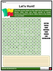
- The economy of Benin is highly dependent on agriculture, cotton production, and regional trade.
- Benin also produces textiles, palm products, cocoa beans, corn, beans, rice, peanuts, cashews, pineapples, cassava, and yams.
CULTURE
- The official language of Benin is French.
- However, there are also several indigenous languages used such as Fon, Bariba, Yoruba, and Dendi.
- The largest religious group in Benin is Catholicism.
- Benin’s literature had a strong oral tradition, but that changed when French became the dominant language of the country.
- The first Beninese novel was written by Félix Couchoro.
- The music of Benin has played an important role in the African music scene as Angélique Kidjo, who is one of the popular African musicians, is a product of Benin.
- The national anthem of Benin is entitled “L’Aube Nouvelle” (The New Dawn).
- Art in Benin is also strong, with its artists gaining international recognition. Some of them include Georges Adéagbo, Meschac Gaba, Romuald Hazoumè, Dominique Zinkpè, and Emo de Medeiros.
- Beninese cuisine is known for its exotic ingredients and flavorful dishes.
- In the southern part of Benin, the most common ingredient is corn.
- In the northern part of Benin, the main staple is yams.
- Football is considered the most popular sport in Benin.
OTHER FACTS
- Benin is part of the United Nations, the African Union, the Economic Community of West African States, the Organisation of Islamic Cooperation, the South Atlantic Peace and Cooperation Zone, La Francophonie, the Community of Sahel–Saharan States, the African Petroleum Producers Association, and the Niger Basin Authority.
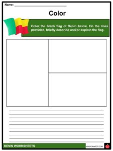
- The flag of Benin consists of two (2) horizontal bands in yellow and red, and one (1) vertical green band.
- The colors of Benin’s flag carry cultural, political, and regional meanings. The yellow and green bands allude to the northern savannas and palm groves. On the other hand, the red band stands for the blood shed by those who fought for Dahomey.
- Benin is considered as the cradle of ‘voodoo’. Voodoo is an official religion of Benin and no other country in the world has considered it as official.
- Cotton constitutes about 80% of the export products of Benin.
Benin Worksheets
This is a fantastic bundle which includes everything you need to know about the Benin across 23 in-depth pages. These are ready-to-use Benin worksheets that are perfect for teaching students about the Benin which is one of the countries in Africa with the most stable democracy.
Complete List Of Included Worksheets
- Benin Facts
- More
- Twelve
- Mix N Match
- Color
- Let’s Hunt!
- Describe
- Complete
- Voodoo
- Beautiful
- Reaction
Link/cite this page
If you reference any of the content on this page on your own website, please use the code below to cite this page as the original source.
Link will appear as Benin Facts & Worksheets: https://kidskonnect.com - KidsKonnect, January 4, 2021
Use With Any Curriculum
These worksheets have been specifically designed for use with any international curriculum. You can use these worksheets as-is, or edit them using Google Slides to make them more specific to your own student ability levels and curriculum standards.