Premium
 Download
Edit
Download
Edit
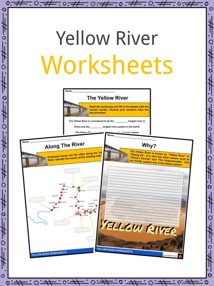
Download the Yellow River Facts & Worksheets
Click the button below to get instant access to these worksheets for use in the classroom or at a home.
Download This Worksheet
This download is exclusively for KidsKonnect Premium members!
To download this worksheet, click the button below to signup (it only takes a minute) and you'll be brought right back to this page to start the download!
Sign Me Up
Edit This Worksheet
Editing resources is available exclusively for KidsKonnect Premium members.
To edit this worksheet, click the button below to signup (it only takes a minute) and you'll be brought right back to this page to start editing!
Sign Up
Not ready to purchase a subscription? Click to download the free sample version Download sample
Download This Sample
This sample is exclusively for KidsKonnect members!
To download this worksheet, click the button below to signup for free (it only takes a minute) and you'll be brought right back to this page to start the download!
Sign Me Up
Table of Contents
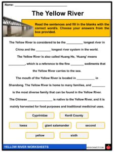
The Yellow River, also known as Huang He, is best known as the second-longest river in China and sixth-longest river system in the world.
See the fact file below for more information on the Yellow River or alternatively, you can download our 23-page Yellow River worksheet pack to utilise within the classroom or home environment.
Key Facts & Information
HISTORY
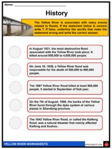
- The Yellow River has been involved in several deadly floods that have happened in the history of China. Some of these deadly floods include the 1332-1333 flood during the Yuan dynasty, the 1887 flood during the Qing dynasty, and the 1931 flood during the Republic of China era.
- The 1887 Qing dynasty flood killed around 900,000 to 2 million people, while the 1931 Republic of China flood killed around 1 million to 4 million people.
- The main cause of these floods is the large amount of fine-grained loess that the river carries from the Loess Plateau.
- The sedimentation creates natural dams, and due to the enormous amount of water, the water has to find new ways to the sea, which eventually causes floods.
BASIC INFORMATION
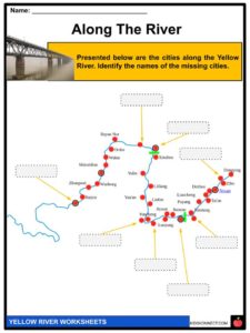
- The Yellow River rises in southern Qinghai province on the Plateau of Tibet and then crosses six provinces and two autonomous regions.
- These include Qinghai, Gansu, Ningxia, Inner Mongolia, Shaanxi, Shanxi, Henan, and Shandong.
- Currently, the mouth of the Yellow River is located in Kenli County in in Shandong.
- The following are the tributaries of the Yellow River: White River, Black River, Datong River, Daxia River, Tao River, Zuli River, Qingshui River, Dahei River, Kuye River, Wuding River, Fen River, Wei River, Luo River, Qin River, Dawen River, and Kuo River.
GEOGRAPHY
- The Yellow River is divided into three parts: a mountainous upper course, a middle course across a plateau, and a lower course across a low plain.
- The upper course of the river crosses two large bodies of water, Ngoring Lake and Gyaring Lake. These bodies of water are rich in fish but freeze over during the winter season.
- The upper course consists mainly of inaccessible, highly mountainous, sparsely populated terrain with a cold climate.
- The middle course flows northeast through the sandy soils of Ningxia and Ordos Plateau.
- Then, the river turns eastward and flows through the alluvial plains in Inner Mongolia.
- The river then turns southward and forms the border between the Shaanxi and Shanxi provinces.
- The lower course flows through Henan and Shandong provinces across the North China Plain.
- The Yellow River has changed its course across the North China Plain several times. Due to this, inhabitants of the region have built extensive systems of levees and irrigation works in an attempt to control the river’s flow.
- The tributaries of the Yellow River include the White River, Black River, Huang Shui, Daxia River, Tao River, Zuli River, Qingshui River, Dahei River, Kuye River, Wuding River, Fen River, Wei River, Luo River, Qin River, Dawen River, and Kuo River.
- There are also bridges and ferries situated along the Yellow River.
- Some of these include the Jinan Yellow River Bridge, Luokou Yellow River Railway Bridge, Kaifeng Yellow River Bridge, Yinchuan Yellow River Bridge, and Zhongshan Bridge.
BIODIVERSITY
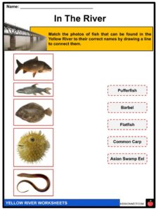
- The Yellow River is rich in fish. However, due to overfishing, habitat loss, and pollution, there has been a decline in the fish population.
- Cyprinidae is the most diverse family in the Yellow River basin.
- Some other families that can be found in the Yellow River include stone loaches, gobies, true loaches, and bagrid catfish.
- The upper part of the Yellow River is dominated by salmonids.
- In contrast, the lower part of the Yellow River is home to many brackish species, like gobies, Asian seabasses, flatfish, and Takifugu pufferfish.
- Other fish in the Yellow River include Asian carp, northern snakehead, and Asian swamp eel.
- Two turtle species are native to the Yellow River basin. These two species are the Chinese pond turtle and the Chinese softshell turtle.
- The Chinese giant salamander is native to the Yellow River and to other Chinese rivers. It is largely farmed for food and traditional medicinal uses.
STATUS
- Severe pollution due to factory discharges, wastes, and other factors has made parts of the Yellow River unusable for agricultural and industrial use.
- The Yellow River and its floods have been central to the legend, folklore, and written history of Chinese civilization.
EXPLORATION
- Nikolay Mikhaylovich Przhevalsky, a Russian traveler, was the first European to explore the upper reaches of the Yellow River in 1879 and 1884.
- Systematic study of the river basin was first done in the 1950s by Chinese and Soviet scientists.
Yellow River Worksheets
This is a fantastic bundle which includes everything you need to know about the Yellow River across 23 in-depth pages. These are ready-to-use Yellow River worksheets that are perfect for teaching students about the Yellow River, also known as Huang He, which is best known as the second-longest river in China and sixth-longest river system in the world.
Complete List Of Included Worksheets
- Yellow River Facts
- The Yellow River
- Along The River
- Why?
- History
- Tributaries
- In The River
- Turtle Species
- Salamander
- Let’s Clean!
- Documentary
Link/cite this page
If you reference any of the content on this page on your own website, please use the code below to cite this page as the original source.
Link will appear as Yellow River Facts & Worksheets: https://kidskonnect.com - KidsKonnect, May 27, 2020
Use With Any Curriculum
These worksheets have been specifically designed for use with any international curriculum. You can use these worksheets as-is, or edit them using Google Slides to make them more specific to your own student ability levels and curriculum standards.