Premium  Download Edit
Download the Appalachian Mountain Facts & Worksheets
Click the button below to get instant access to these worksheets for use in the classroom or at a home.
Download This Worksheet
This download is exclusively for KidsKonnect Premium members!
To download this worksheet, click the button below to signup (it only takes a minute) and you'll be brought right back to this page to start the download!
Sign Me Up
Edit This Worksheet
Editing resources is available exclusively for KidsKonnect Premium members.
To edit this worksheet, click the button below to signup (it only takes a minute) and you'll be brought right back to this page to start editing!
Sign Up
Not ready to purchase a subscription? Click to download the free sample version Download sample
Download This Sample
This sample is exclusively for KidsKonnect members!
To download this worksheet, click the button below to signup for free (it only takes a minute) and you'll be brought right back to this page to start the download!
Sign Me Up
Table of Contents
The Appalachian Mountains span over 2,000 miles (3,200 km) from Newfoundland and Labrador in Canada to middle Alabama in the United States and act as a natural divider between the vast Eastern Coastal Plain and North America’s interior lowlands. They have been essential to the colonization and growth of the whole continent. They blend a history of scenic beauty and a unique regional culture with current economic hardship and environmental degradation issues.
See the fact file below for more information on the Appalachian Mountain, or you can download our 33-page Appalachian Mountain worksheet pack to utilize within the classroom or home environment.
Key Facts & Information
PHYSIOGRAPHY
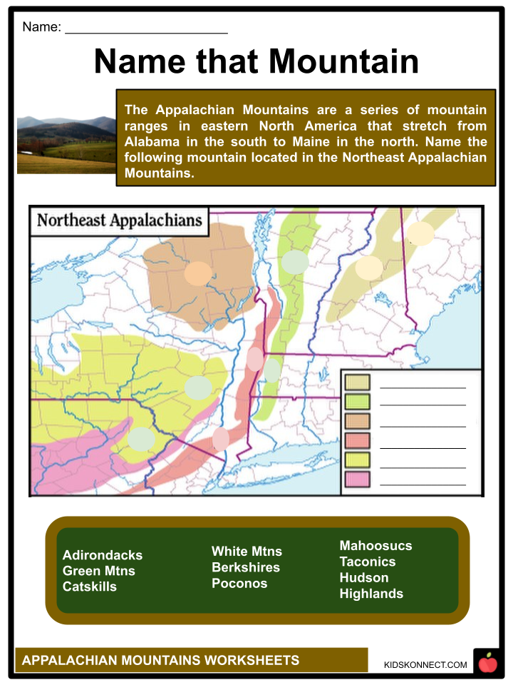
- The Appalachian Mountains are divided into three major physiographic regions: northern, central, and southern Appalachia. The northern region includes mountains such as the Shickshocks, Notre Dame, Long Range, Mount Katahdin, Green Mountains, and White Mountains. Central Appalachia encompasses the Catskill Mountains, the beginnings of the Blue Ridge range, and the Allegheny Mountains in Pennsylvania, Maryland, and Ohio.
- The southern region consists of the Alleghenies, Blue Ridge range, Unaka Mountains (including the Great Smoky Mountains), and Cumberland Mountains.
- The northern section has the highest altitudes, with peaks like Mount Katahdin and Mount Washington reaching over 5,000 feet.
- In the southern region, mountains like the Black Mountains and the Great Smoky Mountains exceed 6,000 feet, making it the highest part of the Appalachian system.
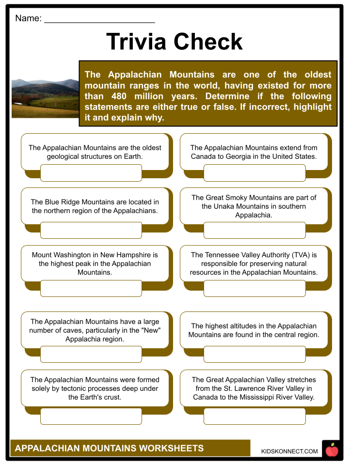
- The Great Appalachian Valley is a prominent feature of the region, stretching from the St. Lawrence River valley in Canada to the Kittatinny, Cumberland, Shenandoah, and Tennessee valleys in the United States.
- The Tennessee Valley Authority (TVA), a government organization focused on natural resource preservation, electricity generation, and regional development, is located in this valley.
- The Appalachian Mountains also feature numerous caves, primarily in the geologically known “New” Appalachia region.
- Caves form in areas with softer limestone rocks dissolved by water and weak acids.
- The most notable caverns are found in the Great Valley region spanning Pennsylvania, Maryland, West Virginia, Virginia, and Tennessee.
- The central and southern Appalachia regions also have a variety of subterranean tunnels, chambers, watercourses, and formations, with the Shenandoah Valley in Virginia being particularly famous for its spectacular caverns.
GEOLOGY
- The Appalachian Mountains, among the oldest geological structures on Earth, were formed through a combination of deep tectonic processes and surface water activity.
- The mountains consist of two types of rocks that reveal their extensive history.
- The oldest rocks are crystallized and metamorphic, formed through sedimentation and volcanic activity around 1.1 billion to 541 million years ago.
- These rocks, such as gneisses, marble, slate, schist, and quartzite, predate most life forms and lack fossil evidence.
- They are found in New England, the Blue Ridge region, and “Old” Appalachia in Canada.
- The second type of rock in the Appalachian is sedimentary and of Paleozoic age, approximately 252 to 541 million years old.
- These rocks, including shales, sandstones, limestones, and coals, were deposited and cemented over geological time, forming “New” Appalachia.”
- The process of sedimentation also created rich coal beds between 358.9 and 298.9 million years ago. The Permian Age, around 298.9 to 252.2 million years ago, witnessed significant folding and crumpling of the mountains, known as the Appalachian Revolution.
- The shaping of the Appalachians involved the forces of ice and water, along with the immense folding of the Alleghenian orogeny.
- The mountains have been continually built, eroded, elevated, and sculpted over time.
- The major rivers in Virginia flow northeast into the Atlantic Ocean due to the mountains’ younger age, while rivers flow southwest to the Ohio River, encountering breathtaking canyons, gorges, and water gaps.
- Glacial pressures also affected the northern Appalachians during the Pleistocene Epoch, between 2,588,000 and 11,700 years ago. Continental ice sheets covered New England and impacted the landscape, pushing plants and animals farther south.
- When the glaciers receded, the southern Appalachians provided a refuge for northern life forms and became a fertile ground for botanical diversity as plants slowly migrated back north.
DRAINAGE
- The New River in North Carolina’s Blue Ridge flows north, then west through the Appalachian Valley and the Alleghenies before joining the Mississippi River basin.
- However, some rivers in the south, under the jurisdiction of the Tennessee River, are exceptions. Additionally, there is a complex network of rivers, springs, streams, and water features throughout the Appalachian system, with the Southern Appalachians having the most water.
- The Blue Ridge region receives around 70 inches of precipitation annually, and the Great Smoky Mountains can receive up to 90 inches, ranking it among the wettest areas in the country.
- Due to the absence of natural reservoirs, sudden rains cause rapid rises in stream flows in the southern Appalachian region.
- This area also lacks the glacial deposits found in the northern Appalachian region.
- As a result, the region has a history of devastating floods and debris flows, often triggered by hurricanes and intense rainfall.
- The Tennessee Valley Authority (TVA) was established in 1933 to control floods and harness the river system’s power for various purposes, including navigation, power generation, land reclamation, and watershed development.
- The TVA’s damming technology transformed the river into a more controlled and productive system, creating large reservoirs known as the “Southern Great Lakes.”
- By utilizing water power for electricity, the TVA stimulated industrial, agricultural, and recreational opportunities, significantly impacting the environment and resources of the Southern Appalachian region.
- Waterfalls are common throughout the Appalachian system. In the northern Appalachians, they often form by glacial moraine or debris consolidated into shelves over which water cascades.
- In the Southern Appalachians, the water interacts with alternating layers of soft and hard rock, leading to waterfall formation.
CLIMATE
- The Appalachians’ climate, which is typically moderate and humid, offers stark variations. Arctic and subarctic climates are predominant in the Canadian ranges and the Presidential Range of the White Mountains.
- The weather is often warmer in the hills of northwestern Georgia, northeastern Alabama, and north-central Alabama at elevations below 2,000 feet.
- The White Mountains, Newfoundland’s Long Range, and the Shickshocks receive the most snowfall, while Mount Mitchell in North Carolina has had more than 100 inches of snowfall in a single year.
- Mount Washington, a lonely mountain covered in boulders and battered by some of the world’s fiercest winds (a gust of 231 miles per hour was recorded there in 1934), is exceptional in terms of climate severity.
- The summit’s temperatures have never exceeded 71 °F (22 °C).
- The Appalachians frequently see dense clouds and haze, which hinder outdoor leisure and sightseeing but benefit the region’s rich plant life and river system.
PLANTS AND ANIMALS
- The Appalachian Mountains chain stretches from Maine to Georgia and was formerly nearly entirely covered by forest.
- The Appalachians and surrounding regions, particularly southern Appalachia, continue to support some of the largest and most extensive broad-leaved deciduous forests in the world today.
- The northern hardwoods (sugar maple, buckeye, beech, ash, birch, and red and white oak) and conifers (red spruce and balsam fir, which grow at the highest elevations and characterize the Canadian and Maine forests) are found there.
- Hickory, poplar, walnut, sycamore, and at one time, the significant and abundant chestnuts—before trees were eradicated by blight—are located further south.
- The southern mountain area is home to all of them as well as the other 140 species of Appalachian trees.
- The western slopes of the Great Smokies, with their ample rainfall, generate trees that have reached record maximum height and diameter, while lofty heights sustain representatives of a Canadian forest.
- These include the chestnut oak, buckeye, eastern (Canadian) hemlock, and tulip tree (yellow poplar).
- The “Appalachian forest” is a complex interdependent system of plant development in the southeastern United States.
- One of the largest floral provinces on Earth is formed by it. Serviceberry, redbud, hawthorn, tulip tree, dogwood, locust, sourwood, and many more trees have profuse blooms.
- Rhododendron, azalea, and mountain laurel are a few of the countless bushes with exceptionally eye-catching blossoms. The southern Appalachians have several peaks known as “heath balds,” which feature broad meadows or grasslands scattered with dense heath growths.
- One of the largest is Roan Mountain in the North Carolina-Tennessee Unakas, with 1,200 acres of natural gardens strewn across its high pinnacle and down its slopes with vibrant rose and pink and purple rhododendron.
- Two of the 2,000 species of Appalachian flora are thought to be native and exclusive to the southern Appalachians.
- The intricate plant life of the Appalachians also includes ferns, mosses, and several types of fungi.
- Elk have now returned to the northern highlands, but bison, elk, and wolves, previously widespread in the Appalachians, have long since vanished.
- However, the most northern regions of the nation are still home to caribou and moose.
- Black bears, white-tailed deer, wild boar, foxes, raccoons, beavers, and several other small animals are common in the forest.
- From the Gaspé Peninsula to Georgia, all parts of Appalachia are home to a thriving bird population. Around 200 different species of game birds and songbirds have been identified in the Great Smoky Mountains alone.
THE PEOPLE AND THE ECONOMY
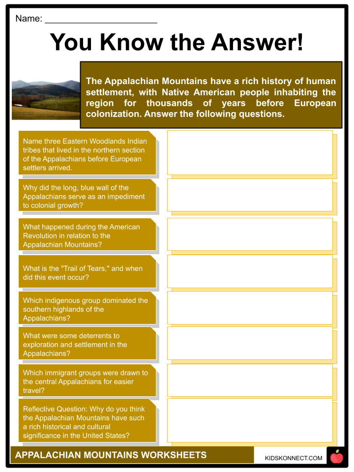
- Settlement and expansion- Before European settlers arrived, many Eastern Woodlands Indian tribes, including the Pennacook, Mohican (Mahican), and Susquehanna, lived in the northern section of the Appalachians.
- The Cherokee dominated the southern highlands.
- By the middle of the 19th century, war and eviction had removed the majority of Indian inhabitants from the highlands.
- The “Trails of Tears,” the most well-known instance of Indian removal, is the name given to the forced transfer of the Cherokees from North Carolina to Oklahoma through the fall and winter of 1838–1839.
- The Appalachians’ long, blue wall was a powerful impediment to colonial growth. The breadth and intricacy of the lateral mountain ranges, the rocky courses of many of the streams and rivers, and the thick forest were further deterrents to exploration and settlement.
- The majority of early immigrants were drawn to the central Appalachians because of the large water gaps that made travel easier.
- Many of these were Germans and Scotch-Irish people who traveled into Pennsylvania’s interior before moving on to Virginia and Tennessee via the Great Appalachian Valley.
- Both the massive ruggedness of the successive ranges in the southern Appalachians and the narrow notches, frequently blocked by glacial debris, in the New England Appalachians discouraged early settlement; thus, each of these regions remained a wilderness long after the American frontiersman Daniel Boone had carved his pioneer path through the Cumberland Gap.
- Central Appalachia was the path to the Ohio area and the Great Lakes during the French and Indian War (1754–1763), and these routes, with their dispersed, isolated interior forts, became savage border battlegrounds.
- During the American Revolution (1775–1833), British Indian allies attacked Appalachian villages in violent clashes, but the Appalachian Mountains kept most of this war confined to the Eastern Seaboard.
- Economic growth- The mineral resources of the system exhibit the same diversity as the plant and animal life that is unique to the Appalachian region.
- Similar to how the vast stands of forest found across the Appalachians gave rise to significant lumber and wood-pulp businesses, the region’s rich coal beds, iron ore veins, salt springs and licks, and granite and marble resources all gave rise to significant American industries.
- Each industry has been accompanied by specific issues unique to it, particularly in the area of conservation.
- For instance, the destruction of land and human resources caused by some coal mining operations and the contamination of Appalachian streams by the pulp and chemical industries.
- From North Carolina to Canada, the Appalachian woodlands have suffered damage from air pollution, particularly in the form of acid rain and fog.
- The Appalachian Mountains’ highest point, Mount Mitchell, once known as Black Dome for its thick covering of virgin evergreens, is now covered in a ghost forest of dead trees.
- Some parts of Appalachia remained remote until the early 20th century, particularly those mountainous regions of the southern region where difficult topography prevented road construction, despite the early entrance of the timber industry and the opening of the coal mines.
- As a result, the Southern Appalachian highlanders created a distinctive culture that is represented by handicrafts, songs, folklore, and mores that both acknowledge and celebrate the region’s enormous challenges and tremendous possibilities.
RECREATION AND TOURISM
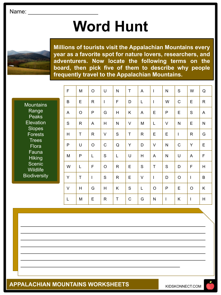
- One of North America’s top recreational hubs has emerged in the Appalachian region.
- A significant stretch of the system’s 2,100-mile (3,400-km) Appalachian Trail is one of its distinctive features.
- This trail offers hikers a grandstand view of the diverse Appalachian Mountains as it connects Mount Katahdin in Maine with Springer Mountain in Georgia.
- Along the highway, there are a few locations to stay.
- In northern Virginia, the 469-mile (755-kilometer) private Blue Ridge Parkway connects the Great Smoky Mountains and Shenandoah National Parks.
- In the spring, a major tourist drawcard in the Appalachians is the abundance of wild azaleas, rhododendron, and laurel that bloom.
- This phenomenon starts in the south in April and spreads northward. When the leaves turn bright colors in the fall, the pattern is reversed, and the foliage flows from north to south.
- The Appalachians are a great place to go driving, hiking, camping, fishing, skiing, whitewater rafting, and spelunking.
- There are also many craft shops and historical places to explore.
- While conference centers and theme parks represent an increasing emphasis on tourism, with their accompanying advantages and challenges of environmental stress, they also serve as recollections of more leisurely days in both the northern and southern highlands.
Appalachian Mountain Worksheets
This fantastic bundle includes everything you need to know about Appalachian Mountain across 33 in-depth pages. These ready-to-use worksheets are perfect for teaching kids about Appalachian Mountain. They blend a history of scenic beauty and a unique regional culture with current economic hardship and environmental degradation issues.

Complete List of Included Worksheets
Below is a list of all the worksheets included in this document.
- Appalachian Mountains Facts
- Trivia Check
- Name that Mountain
- Word Hunt
- You Know the Answer!
- Appalachian Forest
- History of Appalachia
- 2 Pics 1 Activity
- Fauna of Appalachia
- May Favorite Part
- Diorama
Frequently Asked Questions
What is the Appalachian Mountain Range?
The Appalachian Mountains are a vast mountain range that stretches along the eastern part of North America, spanning from Newfoundland and Labrador in Canada to Alabama in the United States. It is one of the oldest mountain ranges in the world.
How long is the Appalachian Trail?
The Appalachian Trail is a famous hiking trail that runs through the Appalachian Mountains. It spans approximately 2,200 miles (3,500 kilometers) from Springer Mountain in Georgia to Mount Katahdin in Maine, making it one of the longest hiking trails in the world.
What states does the Appalachian Mountains pass through?
The Appalachian Mountains pass through or are located in the following states: Alabama, Georgia, South Carolina, North Carolina, Tennessee, Kentucky, Virginia, West Virginia, Ohio, Maryland, Pennsylvania, New York, New Jersey, Connecticut, Massachusetts, Vermont, New Hampshire, and Maine.
What is the significance of the Appalachian Mountains?
The Appalachian Mountains hold great ecological, cultural, and historical significance. They are home to diverse plant and animal species, including several endangered ones. The region is rich in natural resources and has a rich cultural heritage, including the traditions of Native American tribes and early European settlers.
Are there any national parks in the Appalachian Mountains?
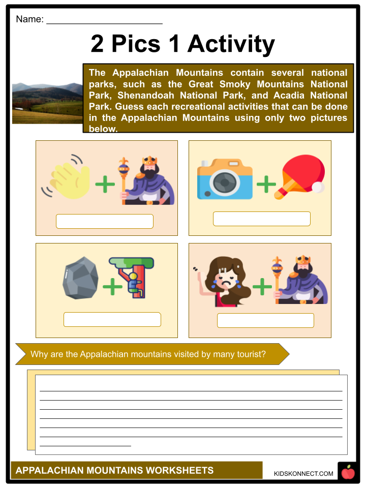
Yes, there are several national parks and protected areas within the Appalachian Mountains. Some notable examples include Great Smoky Mountains National Park (shared by Tennessee and North Carolina), Shenandoah National Park (Virginia), Acadia National Park (Maine), and the Appalachian National Scenic Trail.
Link/cite this page
If you reference any of the content on this page on your own website, please use the code below to cite this page as the original source.
Link will appear as Appalachian Mountain Facts & Worksheets: https://kidskonnect.com - KidsKonnect, July 19, 2023
Use With Any Curriculum
These worksheets have been specifically designed for use with any international curriculum. You can use these worksheets as-is, or edit them using Google Slides to make them more specific to your own student ability levels and curriculum standards.


