Premium  Download Edit
Download the Great Dividing Range Facts & Worksheets
Click the button below to get instant access to these worksheets for use in the classroom or at a home.
Download This Worksheet
This download is exclusively for KidsKonnect Premium members!
To download this worksheet, click the button below to signup (it only takes a minute) and you'll be brought right back to this page to start the download!
Sign Me Up
Edit This Worksheet
Editing resources is available exclusively for KidsKonnect Premium members.
To edit this worksheet, click the button below to signup (it only takes a minute) and you'll be brought right back to this page to start editing!
Sign Up
Not ready to purchase a subscription? Click to download the free sample version Download sample
Download This Sample
This sample is exclusively for KidsKonnect members!
To download this worksheet, click the button below to signup for free (it only takes a minute) and you'll be brought right back to this page to start the download!
Sign Me Up
Table of Contents
The Great Dividing Range, also known as the Eastern Highlands, is a mountain range system in eastern Australia that includes many mountain ranges, plateaus, and rolling hills. It is the world’s fifth-longest land-based mountain chain and the only one entirely contained within a single country.
See the fact file below for more information on the Great Dividing Range, or you can download our 32-page Great Dividing Range worksheet pack to utilize within the classroom or home environment.
Key Facts & Information
HISTORY
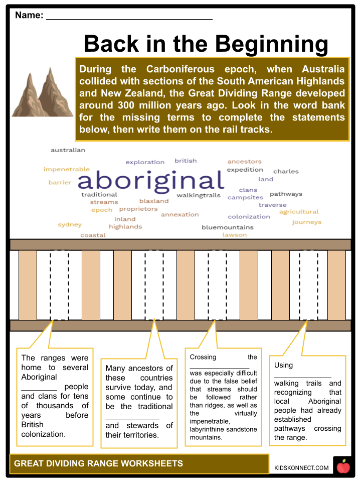
- During the Carboniferous epoch, when Australia clashed with sections of South American highlands and New Zealand, the Great Dividing Range developed around 300 million years ago.
- The ranges were home to several Aboriginal Australian nations and clans for thousands of years before British colonization. Some vestiges of their old way of life survive, such as decorated caves, campsites, and pathways used to traverse between the coastal and inland regions.
- Many ancestors of these countries survive today, and some continue to be the traditional proprietors and stewards of their territories. Following British annexation in 1788, the mountains posed a barrier to exploration and settlement by British immigrants. Although not particularly high, areas of the highlands were quite rough.
- Crossing the Blue Mountains was especially difficult due to the false belief that streams should be followed rather than ridges, as well as the virtually impenetrable, labyrinthine sandstone mountains.
- They were using Aboriginal walking trails and recognizing that local Aboriginal people had already established pathways crossing the range. An expedition led by Gregory Blaxland, William Lawson, and William Charles Wentworth discovered a usable ridge-top route directly westward from Sydney across the Blue Mountains to Bathurst.
- Allan Cunningham, John Oxley, Hamilton Hume, Paul Edmund Strzelecki, Ludwig Leichhardt, and Thomas Mitchell conducted subsequent journeys over and around the mountains. These explorers were primarily concerned with discovering and acquiring suitable agricultural land.
- The most fertile rangelands next to the mountain ranges had been surveyed and stolen from the original inhabitants by the late 1830s, and some had settled. They included the southern Gippsland and Riverine areas, the northern Liverpool Plains, and Darling Downs.
- Many road and railway links were later developed through the mountains. However, many regions remain isolated to this day. For example, in eastern Victoria, the Great Alpine route is the only significant route that connects the highlands from north to south.
GEOGRAPHY
- The Great Dividing Range is not a single continuous complex (cordillera) of old and complicated geological mountain ranges, plateaus, steep highland regions, and escarpments. The topography is somewhat flat in some spots, with shallow hills. The highlands typically range in elevation from 300 to 1,600 meters (980 to 5,250 feet).
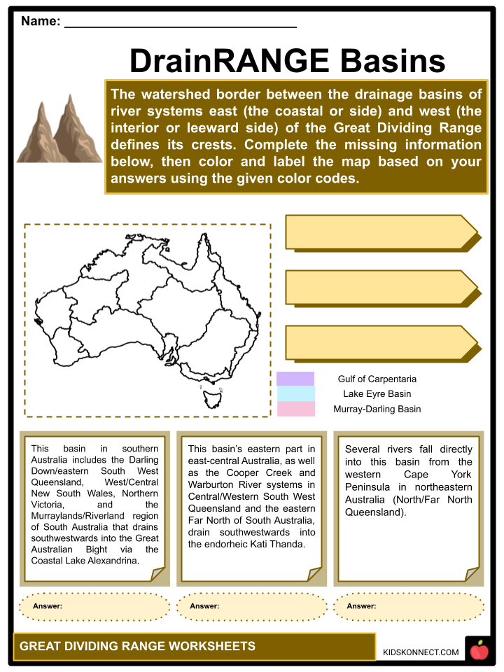
- The watershed barrier separating the catchments of river systems east, which is the coastal or rainward side, and west, which is the interior or leeward side, defines the crests of the Great Dividing Range.
- The phrase “Great Dividing Range” may apply to the range’s watershed crest or the entire upland complex, including the hills and mountains between Australia’s east coast and central plains and lowlands. Rivers east/southeast of the Dividing Range frequently drain directly east into the South Pacific and Tasman Sea or south into the Bass Strait.
- The Murray-Darling basin in southeastern Australia encompasses eastern South West Queensland, Northern Victoria, Central New South Wales, and the Murraylands or Riverland region of southeastern South Australia, which drains southwestwards into the Great Australian Bight through Lake Alexandrina.
- The Cooper River and Warburton Rivers that run in Central South West Queensland and the eastern Far North of South Australia flow southwestwards toward the endorheic Kati Thanda-Lake Eyre.
- Several rivers fall directly into the Gulf of Carpentaria from the western Cape York Peninsula in northeastern Australia (North/Far North Queensland).
CLIMATE
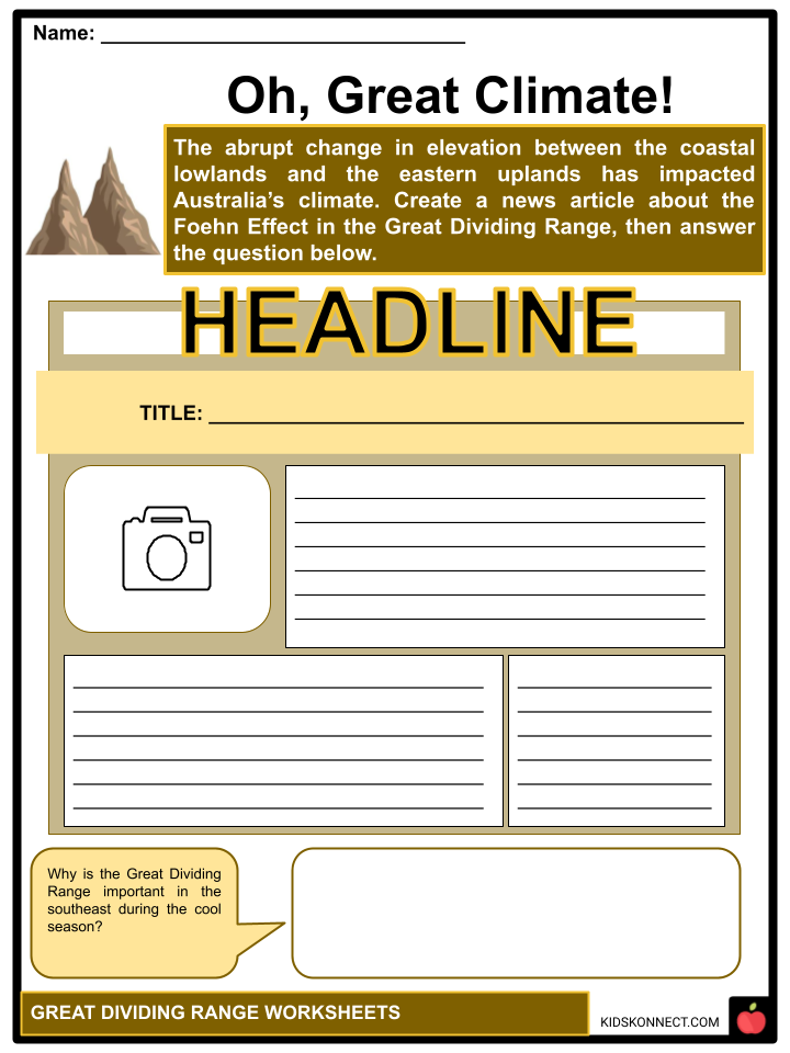
- The abrupt change in elevation between the coastal lowlands and the eastern uplands has impacted Australia’s climate, mainly owing to orographic precipitation, and these places of maximum relief have exposed a magnificent gorge nation.
- The Foehn effect is a dry wind that blows from the Great Dividing Range and rapidly raises air temperature in the range’s shadow while lowering atmospheric moisture in places to the east of the range in southern New South Wales. A partly orographic barrier or somewhat damp low-level air leeward causes this dry breeze, which enhances fire threat throughout the summer.
- During the cool season, the Great Dividing Range would protect much of the southeast (including Sydney, the Central Coast, the Hunter Valley, the Illawarra, the ACT, the Monaro, and the South Coast) from south-westerly polar explodes that develop in the Southern Ocean and bring freezing rain, sleet, and snowfall to the upwind side of the ranges, such as the Central Tablelands, South West Slopes, and Snowy Mountain regions.
- The main resorts for skiing in New South Wales, which include Thredbo Village, Perisher, and Charlotte Pass, are found on the transitional region between the leeward and windward sides, with the former being more leeward and the latter more windward.
- Although they get significant precipitation from the ranges’ crests, they lack the constant cloud cover that distinguishes truly windward places on the western face, which include Cabramurra, Kiandra, Mount Buller, Falls Creek, Mount Hotham, and Mount Buffalo.
Precipitation
- Because the Great Dividing Range inhibits westerly cold fronts from the Southern Ocean (usually between winter and early spring), precipitation is mostly obtained from the Tasman Sea to the east in leeward zones.
- As a result of the Foehn effect, winters in leeward zones are drier, whereas summers are quite moist. Due to the huge distances and the Great Dividing Range, little or no rainfall is received from the Tasman Sea to the east; instead, precipitation is obtained from the South Indian Ocean and the Southern Ocean, traveling eastwards or northeastward over Victoria.
- Winters in windward locations are often rainy, whereas summers are (relatively) dry. Transitional zones generally have consistent rainfall and can be susceptible to westerly fronts and easterly flows.
NATURAL COMPONENTS
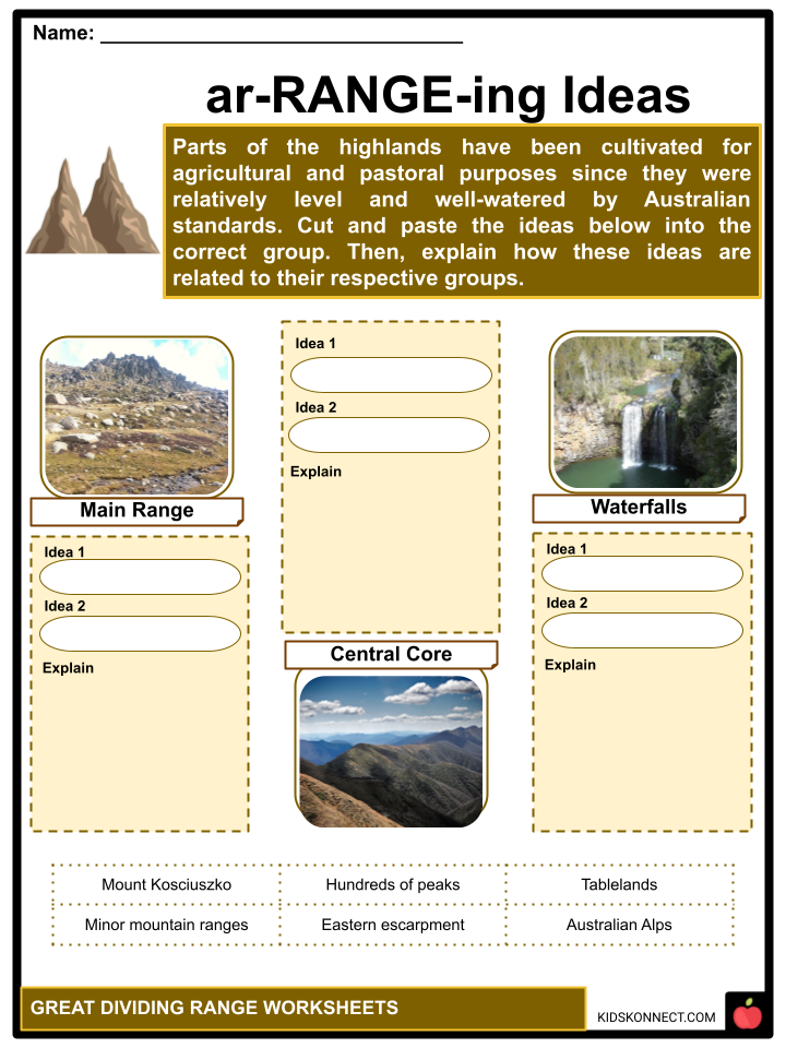
- Parts of the highlands have been cultivated for agricultural and pastoral purposes since they were relatively level and well-watered by Australian standards.
- The Main Range includes all of mainland Australia’s alpine zones, including its highest peak, Mount Kosciuszko (2,228).
- The Australian Alps are the highest regions in southern New South Wales and eastern Victoria. The Great Dividing Range’s central core is peppered with hundreds of peaks and is bordered by other minor mountain ranges or spurs, gorges, basins, and plains of regional significance.
- The highlands represent a considerable barrier in certain locations, such as the Snowy Mountains, Victorian Alps, Scenic Rim, and the eastern escarpments of the New England region.
- The numerous beautiful waterfalls caused by rivers tumbling from the tablelands can be seen on the eastern escarpment. In some regions, the slopes are moderate, and the range is scarcely discernible.
- Canberra, Toowoomba, and the outlying suburbs of Sydney, Melbourne, Brisbane, Gold Coast, and Cairns in north Queensland are major cities located on the range’s upland portions. There are several cities and localities throughout the range, as well as in lowlands and foothill settlements near the highlands.
WATER CATCHMENTS
- The lower levels are utilized for forestry, which is frowned upon by conservationists. The range also provides nearly all of eastern Australia’s water supply, both through dam runoff and throughout much of Queensland via the Great Artesian Basin.
- Valleys throughout the mountain chain have supplied water for significant dams and water delivery projects like the Upper Nepean Scheme, the Snowy Mountains Scheme, and Warragamba Dam.
- The Bradfield Scheme has been recommended as a method of transferring water from the Queensland Wet Tropics in the coastal northeast of Far North Queensland to inward dryer areas through an array of dams and tunnels, involving a tunnel that runs through the Great Dividing Range into the Flinders River, subsequently a passageway into Torrens Creek in the White Mountains National Park, which passes south into Thompson River/Cooper Creek, part of the Eyre Basin.
- The Flinders River, Condamine River, Herbert River, Lachlan River, Macintyre River, Macdonald River, and Namoi River are some rivers that run west of the mountains. The Goulburn, Mitta Mitta, Kiewa, Ovens, Loddon, King, and Campaspe Rivers stream north into the Murray-Darling Basin from Victoria.
- The Brisbane River, Burnett River, Burdekin River, Clarence River, Fitzroy River, Hawkesbury River, Hastings River, Hunter River, Karuah River, Macleay River, Mary River, Richmond River, and Shoalhaven River are among the rivers that meander east into the Pacific Ocean. The Snowy, Cann, Latrobe, Mitchell, Tambo, Thomson, Yarra, Werribee, Hopkins, and Glenelg Rivers run south, mainly through Victoria.
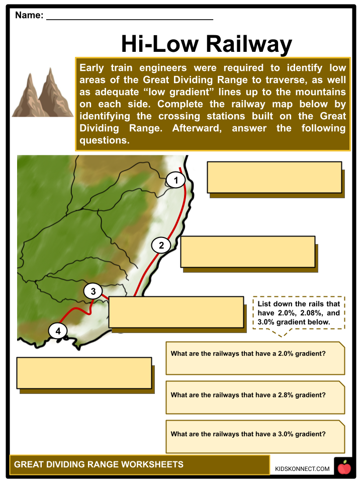
RAILWAYS
- Early train engineers were required to identify low areas of the Great Dividing Range to traverse, as well as adequate “low” gradient lines up the mountains on each side. All rail passes are Townsville-Mt Isa, Rockhampton-Winton, Brisbane-Toowoomba (1867) featuring a 2.0% gradient, Newcastle-Tamworth (1870), and the summit at Ardglen Tunnel (2073′ HASL).
- The Sandy Hollow-Gulgong railway line was built in the 1930s to Maryvale, also known as the Main Western railway line, and finished in the 1980s to Gulgong, the mountain just west of Ulan NSW’s lowest, fourth, and last crossing.
- Crossing the range via the Blue Mountains (peak near Bell 3507′ HASL) with a 3.00% gradient, Sydney-Lithgow (1869). However, the division is a few kilometers farther west towards the intersection with Parkesbourne Road in Cullerin, Sydney-Goulburn (1869).
- The subsequent 300 km descent to Wagga Wagga was initially swift, but caves were introduced in the 1920s. Crossing the range around Heathcote Junction (1872), Melbourne-Seymour (2.08% grade). Traversing the mountain near Woodend (1862) (1093 HASL) between Melbourne and Bendigo. Melbourne-Ararat via Ballarat (1875).
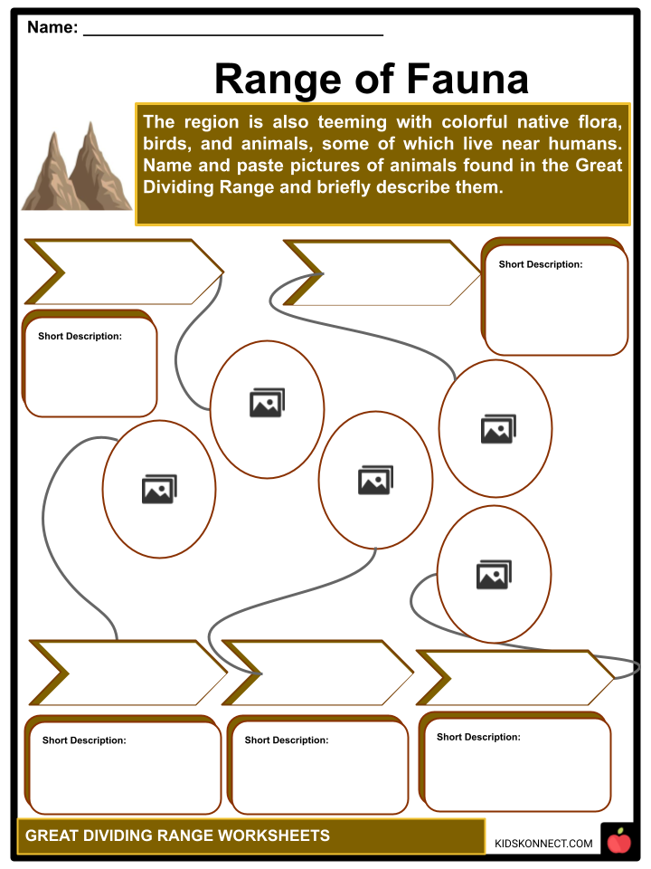
FLORA AND FAUNA
- Thousands of native flora thrive in the bushland, woods, and wilderness regions unique to the Great Dividing Range. The area is also teeming with colorful native birds and animals, some of which live close to humans.
- The Snowy Mountains are home to the Corroboree frog, one of Australia’s most endangered species. Mountain Pygmy Possum is an endangered species. The Common Wombat, Red-necked and Swamp Wallaby, and Eastern Grey Kangaroo are among the large, browsing, and grazed marsupials in the Australian Alps.
PROTECTED AREAS
- Much of the range is protected by a series of national parks and other reserves. The following are the majority of the well-known national parks:
- Alpine National Park in Victoria, northeast of Melbourne, includes much of the Great Dividing Range’s higher terrain, most of Victoria’s skiing, the Bogong High Plains’ subalpine woods, and grassland, and Mount Bogong, Victoria’s highest point.
- The Blue Mountains National Park is located in New South Wales, 81 kilometers (50 miles) west of Sydney, in the Blue Mountains area. Despite its name, the park is a raised plateau cut by many major rivers. It became recognized as part of the Greater Blue Mountains World Heritage Area in 2000.
- The Kosciuszko National Park in the southeastern part of New South Wales comprises 6,900 square kilometers. It is home to Mount Kosciuszko, Australia’s highest peak, and Cabramurra, the country’s highest settlement. The Murray, Snowy, and Murrumbidgee Rivers all originate in this park.
- Grampians National Park is located in Victoria, 235 kilometers (145 miles) west of Melbourne. The Grampians are a stunning collection of sandstone mountain ranges.
- Mount William is the highest point in the area. The park contains several waterfalls that are easily accessible via a well-developed road network. The mountains were named after the Grampian Mountains in Sir Thomas Mitchell’s home Scotland; they are also known as Gariwerd, from one of the native Australian Aboriginal languages, perhaps Jardwadjali or Djab Wurrung.
- The Main Range is a series of mountain ranges and national parks in Queensland, Australia, predominantly in the Tregony area of the Southern Downs Region, about 85 kilometers (53 miles) southwest of Brisbane. It is part of the World Heritage Site of the Gondwana Rainforests of Australia. It encompasses the western half of South East Queensland Scenic Rim, a semicircle of mountains.
Great Dividing Range Worksheets
This fantastic bundle includes everything you need to know about the Great Dividing Range across 32 in-depth pages. These ready-to-use worksheets are perfect for teaching kids about the Great Dividing Range. The Great Dividing Range, also known as the Eastern Highlands, is a mountain range system in eastern Australia that includes many mountain ranges, plateaus, and rolling hills.
Complete List of Included Worksheets
Below is a list of all the worksheets included in this document.
- Great Dividing Range Facts
- Back in the Beginning
- Range of Fauna
- DrainRANGE Basins
- Oh, Great Climate!
- Precipitation Anticipation
- ar-RANGE-ing Ideas
- Hi-Low Railway
- What’s the Catch?
- National Park Hopping
- Great Thoughts
Frequently Asked Questions
What is the Great Dividing Range?
The Great Dividing Range is a mountain range in eastern Australia that stretches more than 3,500 kilometers (2,175 miles) from the northeastern tip of Queensland, through New South Wales and the Australian Capital Territory, and into Victoria. It is one of the longest mountain ranges in the world.
How was the Great Dividing Range formed?
The Great Dividing Range was formed through a combination of geological processes over millions of years. It originated during the Paleozoic Era through the collision of tectonic plates, resulting in the uplifting and folding of the Earth’s crust. Subsequent erosion by rivers and weathering shaped the range into its present form.
What is the significance of the Great Dividing Range?
The Great Dividing Range has significant ecological, economic, and cultural importance. It serves as a watershed, with rivers flowing eastward from the range towards the Pacific Ocean. The range also influences the climate of the region, affecting rainfall patterns and creating distinct ecosystems. Additionally, the range has cultural significance for Indigenous Australian communities and provides recreational opportunities for activities such as hiking and skiing.
What are some notable features or peaks in the Great Dividing Range?
The Great Dividing Range features several notable peaks and landmarks. Mount Kosciuszko, located in the Snowy Mountains of New South Wales, is the highest peak in mainland Australia, reaching 2,228 meters (7,310 feet) above sea level. Other prominent peaks include Mount Bogong in Victoria and Mount Bartle Frere in Queensland. The range also encompasses national parks, such as the Blue Mountains and Lamington National Park.
How does the Great Dividing Range impact the climate of Australia?
The Great Dividing Range plays a crucial role in shaping the climate of eastern Australia. As moist air from the Pacific Ocean encounters the range, it is forced to rise, leading to cooling and condensation. This results in higher rainfall on the windward side (eastern side) of the range, supporting lush forests and agricultural regions. The western side, in contrast, experiences a rain shadow effect, leading to drier conditions and the formation of semi-arid and arid regions further inland.
Link/cite this page
If you reference any of the content on this page on your own website, please use the code below to cite this page as the original source.
Link will appear as Great Dividing Range Facts & Worksheets: https://kidskonnect.com - KidsKonnect, August 16, 2023
Use With Any Curriculum
These worksheets have been specifically designed for use with any international curriculum. You can use these worksheets as-is, or edit them using Google Slides to make them more specific to your own student ability levels and curriculum standards.


