Premium
 Download
Edit
Download
Edit
Download the Tien Shan Mountains Facts & Worksheets
Click the button below to get instant access to these worksheets for use in the classroom or at a home.
Download This Worksheet
This download is exclusively for KidsKonnect Premium members!
To download this worksheet, click the button below to signup (it only takes a minute) and you'll be brought right back to this page to start the download!
Sign Me Up
Edit This Worksheet
Editing resources is available exclusively for KidsKonnect Premium members.
To edit this worksheet, click the button below to signup (it only takes a minute) and you'll be brought right back to this page to start editing!
Sign Up
Not ready to purchase a subscription? Click to download the free sample version Download sample
Download This Sample
This sample is exclusively for KidsKonnect members!
To download this worksheet, click the button below to signup for free (it only takes a minute) and you'll be brought right back to this page to start the download!
Sign Me Up
Table of Contents
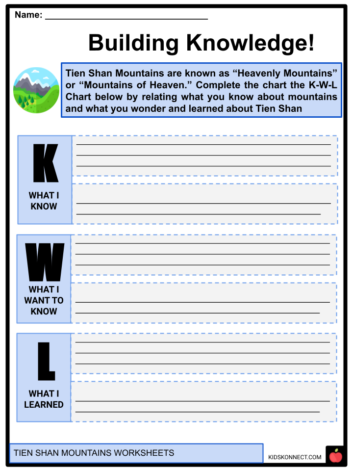
The Tien Shan Mountains is a vast network of mountain ranges, stretching about 1,500 miles (2,500 km) in size, located in Central Asia. The mountain ranges are also referred to as the “Tengri Tagh” or “Tengir-Too,” which means the Mountains of Heaven or the Heavenly Mountain. It is home to Mt. Jengish Chokusu, the highest mountain in Tien Shan.
See the fact file below for more information on the Tien Shan Mountains or you can download our 29-page Tien Shan Mountains worksheet pack to utilize within the classroom or home environment.
Key Facts & Information
BRIEF HISTORICAL BACKGROUND
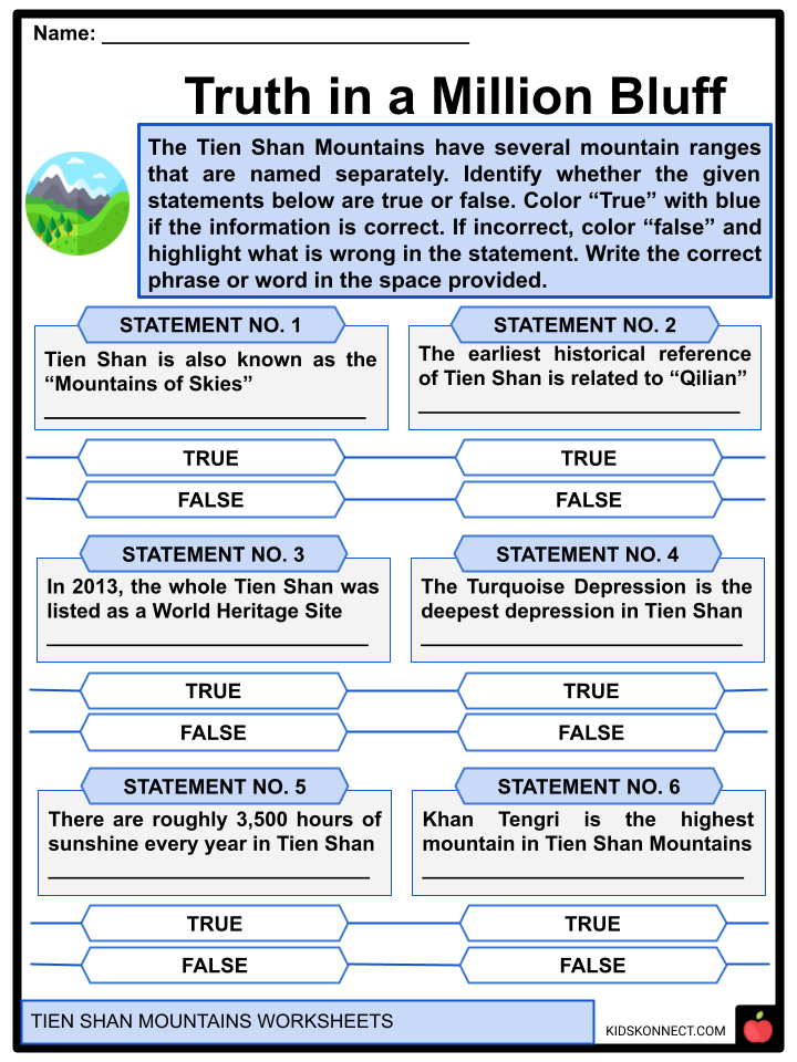
- According to Yan Shigu, a Tang Dynasty commentator, one of the earliest possible historical references to the Tien Shan Mountains is connected to the Xiongnu word “Qilian,” which means “sky” or “heaven.”
- The Han Dynasty historian, Sima Qian, referenced the Qilian Mountains as the ancestral homeland of the Yuezi, the ancient Chinese people, in the “Records of the Grand Historian”. However, it is believed that rather than the Qilian Mountains located 1,500 kilometers to the east, the mountain being referred to is the Tien Shan Mountains.
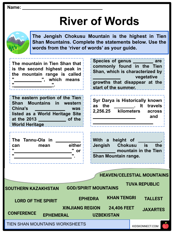
- The name of the Tannu-Ola mountains in the Tuva Republic of Russia conveys the same notion as Tien Shan Mountains. Tannu-Ola can mean either “God/Spirit Mountains” or “Heaven/Celestial Mountains.”
- The mountain in Tien Shan that is the second highest-peak in the mountain range is called “Khan Tengri”, which means “Lord of the Spirit”. The mountain ranges of Tien Shan are considered sacred by the religion of Tengrism.
- The eastern portion of the Tien Shan Mountains in western China’s Xinjiang Region was listed as a World Heritage Site at the 2013 Conference of the World Heritage, while the western portion in Kyrgyzstan, Kazakhstan, and Uzbekistan was then recorded in 2016.
LOCATION
- The mountain range of Tien Shan is located in the border region of Kazakhstan, Kyrgyzstan, Uzbekistan, and Xinjiang in northwest China. It is located to the north and west of the Taklamakan Desert and to the north of the Tarim Basin.
- It connects to the Pamir Mountains in the south and the Mongolian Altai Mountains in the north and east.
- The Tien Shan Mountains belong to the Himalayan Orogenic Belt, which formed colliding plates. In Cenozoic Era, the Indian and Eurasian plates collided, which resulted in the formation of the Himalayan Orogenic Belt.
MOUNTAIN RANGES
- The Tien Shan Mountains are one of the longest mountain ranges in Central Asia, extending from Tashkent, Uzbekistan, 2,900 kilometers eastward. The Tibetan Plateau separates Tien Shan Mountains from the Taklimakan Desert and the Tarim Basin to the south.
- A combination of mountain ranges, intervening valleys, and basins, often moving from east to west, make up the relief. The Turfan Depression, the deepest depression in the eastern Tien Shan, contains the lowest point in Central Asia, which is located at a depth of 505 feet (154 meters) below sea level. As a result, the Tien Shan has significant height differences that surpass 7 km.
- The Tien Shan Mountains have several mountain ranges that are named and often mentioned separately. About 400–600 kilometers east of Ürümqi in China, the Tien Shan begins with the U-shaped Barkol Mountains north of Kumul City. The Bogda Shan, meaning “god mountains”, extend east of Ürümqi for 350 to 40 kilometers.
- The Turfan Depression and Ürümqi are separated by a low area. The Ili River valley and Dzungaria are separated by the Borohoro Mountains, which begin approximately south of Ürümqi and extend 450 kilometers west-northwest. along
- Their northern border is the 200 km long Dzungarian Alatau, which runs along the Sino-Kazakh border in an east-northeast direction. They begin 50 kilometers east of Kazakhstan’s Taldykorgan and conclude at the Dzungarian Gate.
- From the foot of the Borohoros west 570 km (350 mi) to the point where China, Kazakhstan, and Kyrgyzstan meet, the mainline of the Tien Shan continues as the Narat Range in Kyrgyzstan. The Tien Shan is divided into an “eye” to the west of this, with Issyk Kul Lake at its center. The Terskey Alatau is on the lake’s southern shore, and the Kyungey Ala-Too is on its northern shore. The Trans-Ili Alatau runs parallel to and north of the Kyungey Ala-Too in Kazakhstan, just south of Almaty.
ECOLOGY
- Climate. The Tien Shan Mountains’ central location in Eurasia determines its strongly continental climate, typified by significant temperature extremes in both the summer and winter. The surrounding deserts and dry areas demonstrate the region’s distinctive aridity.
- There are roughly 2,500 hours of sunshine every year, and the area absorbs a lot of solar heat. As the mountains rise in elevation, the climate gradually gets colder and drier.
- Above 9,000 feet, there is a significant amount of permafrost or ground with temperatures consistently below 32 °F for two or more years.
- The southern Tien Shan receives the most precipitation between March and April, and the summer months are dry. Most rain occurs in the western and northern Tien Shan during the warm season, peaking in April or May. In the inner and eastern Tien Shan regions, summer is when it rains the most. Because there isn’t much snow there in the winter, several mountain valleys are used as pastures.
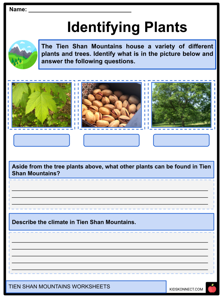
- Plant Life. Xerophytic grasses, wormwood, and species of the desert shrub genus Ephedra are commonly found in the Tien Shan, characterized by ephemeral vegetative growths that disappear at the start of the summer. With a significant admixture of wild fruit trees, the woods on the lower slopes of the outer mountains are primarily made up of maple and aspen (apples and apricots). Ancient nut-bearing forests cover a sizable portion of the Fergana Kyrka Mountains’ southwest slopes. On the forested slopes of numerous western and southern Tien Shan peaks, stands of pistachio, walnut, and juniper.
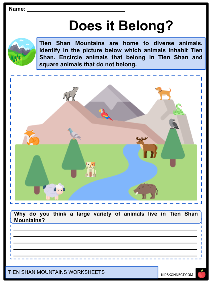
- Animal Life. Diverse organisms can be found in the wide mountain ranges of the Tien Shan Mountains. Wolf, fox and ermine species can be found.
- Other notable Central Asian species include snow leopards, mountain goats, Manchurian roe, roe deer, and mountain sheep, which are primarily found in the high highlands. Bears, badgers, jerboa family members, field voles, wild boars, and Ochotonidae family members live in the forest-meadow-steppe zone.
- The numerous birds include the Himalayan snow cock, mountain partridge, pigeon, alpine chough, crow, mountain wagtail, redstart, and birket. Animals from the nearby plains, including antelopes, gazelles, Tolai hares, and gray hamsters, frequent. Snakes and lizards are also found in the mountain ranges.
NOTABLE SPOTS
- Syr Darya. It is historically known as the Jaxartes. Its source is in the Tien Shan Mountains in Kyrgyzstan and eastern Uzbekistan, and it travels 2,256.25 kilometers across Uzbekistan and southern Kazakhstan to reach the northern Aral Sea remains.
- It is one of the two major rivers in the endorheic basin of the Aral Sea—the other is the Amu Darya—and is located in its northern and eastern portions.
- Ili River. The Ili River flows through Southeast Kazakhstan and Northwest China. It travels from the Xinjiang Uighur Autonomous Region’s Ili Kazakh Autonomous Prefecture to Kazakhstan’s Almaty Region.
- Its length is 1,439 kilometers, 815 of which are in Kazakhstan. The Tekes and Künes rivers in Eastern Tien Shan are the sources of the river. The basin between the Tien Shan and the Borohoro Mountains is drained by the Ili.
- Jengish Chokusu. With a height of 24,406 feet, Jengish Chokusu is the tallest mountain in the Tien Shan Mountain range. It is situated between Wensu County, Xinjiang, China, and the Ak-Suu District, in the extreme eastern Kyrgyz region of Issyk-Kul. It is situated southeast of Lake Issyk Kul and is a portion of the Kakshaal Too, the tallest mountain in the Tien Shan.
- Khan Tengri. It is located east of Lake Issyk Kul on the tripoint of China, Kyrgyzstan, and Kazakhstan. Its glacial icecap rises to 22,999 feet while having a natural elevation of 22,949 feet. Only Jengish Chokusu is higher than Khan Tengri, which is the second-highest mountain in the Tien Shan. The highest point in Kazakhstan is Khan Tengri, which is also Kyrgyzstan’s third-highest mountain.
Tien Shan Mountains Worksheets
This is a fantastic bundle that includes everything you need to know about Tien Shan Mountains across 29 in-depth pages. These are ready-to-use worksheets that are perfect for teaching kids about Tien Shan Mountains, which is a vast network of mountain ranges stretching about 1,500 miles (2,500 km) in size, located in Central Asia.

Complete List of Included Worksheets
Below is a list of all the worksheets included in this document.
- Tien Shan Mountains Facts
- Truth in a Million Bluff
- River of Words
- Recreating a Spot!
- Building Knowledge!
- Let’s Take a Tour!
- Does it Belong?
- Mountain of Words
- Identifying Plants
- Whether the Weather
- Writing History!
Frequently Asked Questions
What type of mountain is Tien Shan?
Spanning an incredible 2,900 kilometers in length and stretching eastward from Tashkent in Uzbekistan, the Tian Shan is part of the mighty Himalayan orogenic belt. It was created due to the collision between two tectonic plates – India’s plate and Eurasia’s – that occurred during the Cenozoic era. As one of Central Asia’s most extended mountain ranges, it is a testament to Earth’s immense power!
How old is Tian Shan?
The grand peaks of the Tien Shan are made mainly of crystalline and sedimentary stones from the Paleozoic Era—between 540-250 million years ago.
Where are the Tien mountains?
The awe-inspiring Tien Shan mountain range spans western China, Kyrgyzstan, and Kazakhstan. Reaching sky-high with its highest peak Mount Pik Pobedy in Kazakhstan at 7,439m tall, this majestic expanse of land is home to one of the world’s most massive lakes, Issyk Kul, nestled near its northeastern end.
Link/cite this page
If you reference any of the content on this page on your own website, please use the code below to cite this page as the original source.
Link will appear as Tien Shan Mountains Facts & Worksheets: https://kidskonnect.com - KidsKonnect, November 30, 2022
Use With Any Curriculum
These worksheets have been specifically designed for use with any international curriculum. You can use these worksheets as-is, or edit them using Google Slides to make them more specific to your own student ability levels and curriculum standards.