Premium  Download Edit
Download the Crater Lake National Park Facts & Worksheets
Click the button below to get instant access to these worksheets for use in the classroom or at a home.
Download This Worksheet
This download is exclusively for KidsKonnect Premium members!
To download this worksheet, click the button below to signup (it only takes a minute) and you'll be brought right back to this page to start the download!
Sign Me Up
Edit This Worksheet
Editing resources is available exclusively for KidsKonnect Premium members.
To edit this worksheet, click the button below to signup (it only takes a minute) and you'll be brought right back to this page to start editing!
Sign Up
Not ready to purchase a subscription? Click to download the free sample version Download sample
Download This Sample
This sample is exclusively for KidsKonnect members!
To download this worksheet, click the button below to signup for free (it only takes a minute) and you'll be brought right back to this page to start the download!
Sign Me Up
Table of Contents
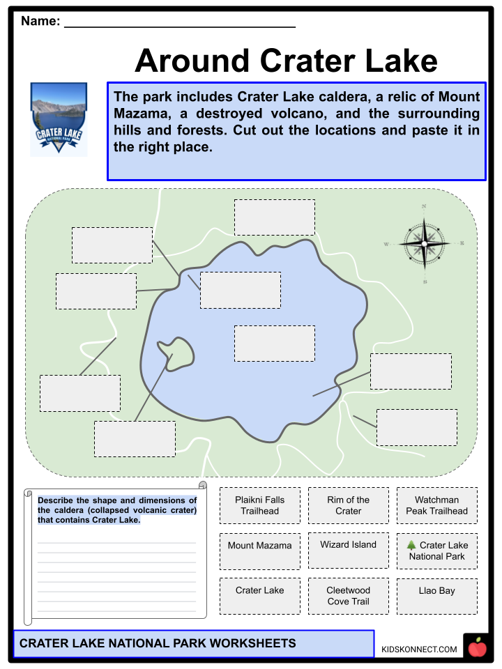
Crater Lake National Park is a national park in southern Oregon, United States. The park comprises the caldera of Crater Lake, a relic of Mount Mazama, a destroyed volcano, as well as the surrounding hills and woods.
See the fact file below for more information about Crater Lake National Park, or you can download our 32-page Crater Lake National Park worksheet pack to utilize within the classroom or home environment.
Key Facts & Information
HISTORY
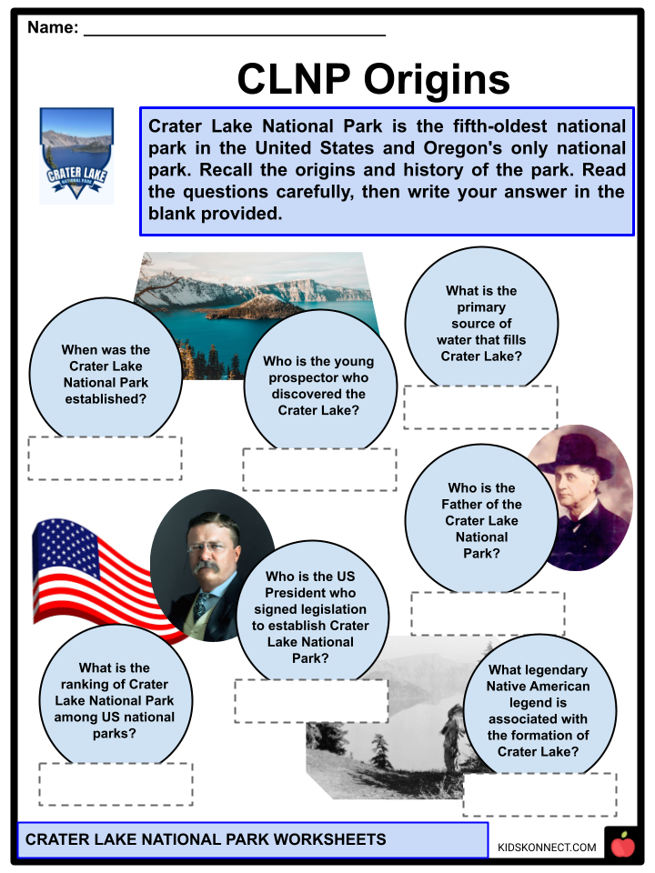
- Crater Lake National Park, established in 1902, is the fifth-oldest national park in the United States and ‘s only national park.
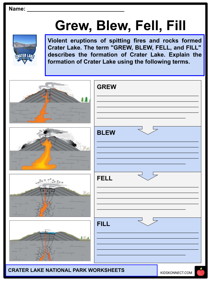
- A powerful eruption shook the 12,000-foot-tall Mount Mazama more than 7,000 years ago, causing the mountain to collapse. The eruption of Mount Mazama led to the creation of Crater Lake.
- The first white people to visit the lake were three gold prospectors named John Wesley Hillman, Henry Klippel, and Isaac Skeeters.
- On June 12, 1853, one of the young prospectors was John Wesley Hillman. They came across the long, sloping mountain and discovered Crater Lake. They named the indigo body of water “Deep Blue Lake,” but the proposed name was later rejected by locals, who preferred the name “Crater Lake.”
- William Steel, an American journalist, devoted his life and fortune to creating and managing Crater Lake National Park. In 1870, he became preoccupied with the lake.
- William Steel is known as the “Father of Crater Lake National Park,” having spent years lobbying and fighting for Crater Lake’s National Park status.
- On May 22, 1902, President Theodore Roosevelt signed legislation establishing Crater Lake National Park, the country’s sixth national park.
GEOGRAPHY
- Crater Lake is located in Klamath County. It is a deep, clear, intensely blue lake in the Cascade Range of southwestern Oregon, about 50 miles (80 kilometers) northeast of Medford.
- Crater Lake National Park, which covers an area of 286 square miles (741 square kilometers), was established in 1902. The park had more than 90 miles (145 km) of hiking trails by the early twenty-first century.
- The crater that formed the lake, about 6 miles (10 km) in diameter, is the remnant of Mount Mazama. This volcano rose to probably 12,000 feet (3,700 meters) before an eruption about 7,700 years ago destroyed the upper portion.
- Crater Lake has an average elevation of 6,173 feet (1,881 meters) above sea level and a depth of approximately 1,500 feet (457 meters).
- Crater Lake is unique among mountain lakes in that there is no streamflow into or out of the caldera. Precipitation, evaporation, and seepage through surrounding rocks influence the lake’s water level.
VOLCANISM
- Mount Mazama is considered active at the moment. Water is known to have a significant influence on the explosivity of an eruption. The mix of water and magma could result in highly violent hydrothermal eruptions that blast rock pieces and big blocks out of the caldera.
- The type of magma, its rate of extrusion, the amount of gas in the magma, and the depth of the water in which it erupts all influence how violently water and magma interact.
- A north-south trending active fault zone runs through the west half of Crater Lake National Park, potentially causing damaging earthquakes.
CLIMATE
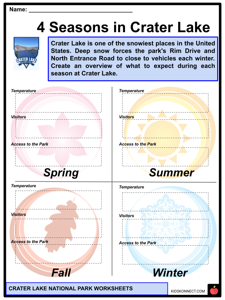
- Crater Lake National Park has a dry-summer subarctic climate according to the Köppen climate classification system. The lake is in plant hardiness zone 6b, with an average annual extreme minimum air temperature of -3.7 °F (-19.8 °C).
- Winter at the park usually begins in September and lasts until June, with an average of 101 days of measurable snowfall. In 1937, 1951, and 1971, the park received up to 37 inches (94 cm) of snow in a single day, 313 inches (800 cm) in a month (January 1950), and 903 inches (2,290 cm) in a year (1950).
- Snow usually accumulates to depths of 10 to 15 feet (3.0 to 4.6 m) in the park by early spring. Snowfall is unusual in July and August, and “one magnificent day usually follows another.”
- December is the coldest month, with highs around 33 °F (1 °C) and lows around 19 °F (7 °C). August is the warmest month, with average highs around 69 °F (21 °C) and lows around 42 °F (6 °C). The highest temperature recorded was 100 °F (38 °C), and the lowest was 21 °F (29 °C). The annual precipitation totals about 67 inches (1,700 mm). The wettest month is December, with an average of 11 inches (280 mm).
- Considering the fact that snow surrounds Crater Lake National Park for eight months of the year (average annual snowfall is 463 inches (1,180 cm), the lake rarely freezes over, due in part to a relatively mild onshore flow from the Pacific Ocean.
FLORA AND FAUNA
- The park’s ecology ranges from mixed conifer woods dominated by ponderosa pine in the south to high-elevation mountain hemlock and whitebark pine forests at the rim.
- The park serves as a haven for native forest and meadow communities. There are also layers of aquatic moss in the lake itself.
- The 180,000+ densely forested acres of Crater Lake National Park high in the Cascade Mountains are home to various plants and creatures.
- Canadian lynxes, bobcats, beavers, chipmunks, pronghorns, foxes, squirrels, porcupines, black bears, coyotes, pikas, badgers, deer, elk, muskrats, and martens are all residents of this national park.
- Birds that frequent this park, including raptors, include American dippers, Peregrine falcons, ravens, Clark’s nutcrackers, Canada jays, bald eagles, hummingbirds, and spotted owls, while Canada geese float on its lake.
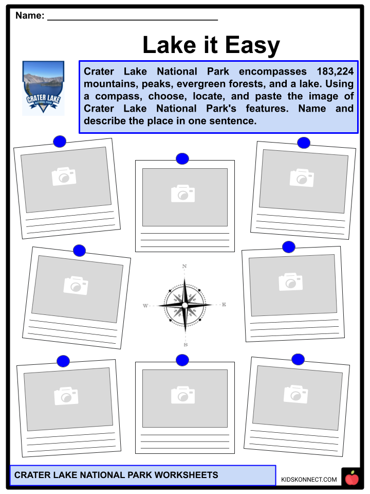
PARK FEATURES
- The Pumice Desert. A thick layer of pumice and ash leads from Mazama to the north. Due to excessive porosity and poor soil composed primarily of regolith, this area is mainly devoid of plants even after thousands of years.
- The Pinnacles. When the scalding ash and pumice landed near the volcano, it formed gas-charged deposits 200 to 300 feet thick. Hot gas rose to the surface and slowly cemented ash and pumice together in channels before escaping through fumaroles for years. Later, the surrounding loose ash and pumice eroded, leaving tall pinnacles and spires.
- Mount Scott. A steep andesitic cone formed by magma from Mazama’s magma chamber; geologists refer to such volcanoes as parasitic or satellite cones.
- Union Peak. An extinct volcano whose primary remains are a large volcanic plug formed by solidified lava in the volcano’s neck.
- Crater Peak. A shield volcano composed primarily of andesite and basalt lava flows, with andesitic and dacite tephra on top.
- Timber Crater. A shield volcano in the northeast corner of the park. It consists of basaltic and andesitic lava flows, like Crater Peak, but two cinder cones top it.
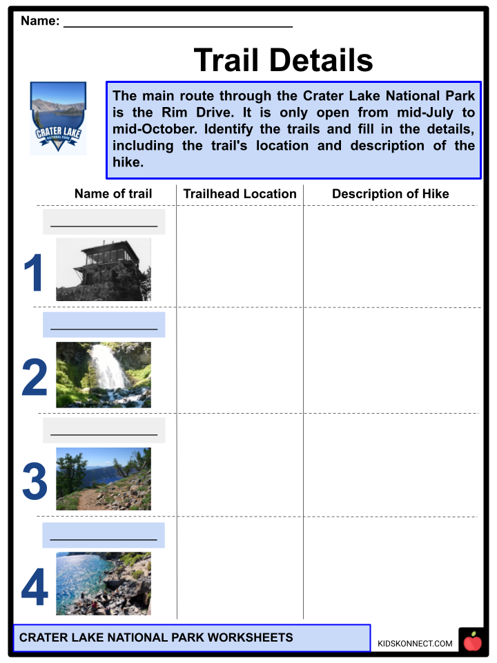
- Rim Drive. The park’s most famous road, it takes a scenic route around the caldera rim.
- Llao Rock. The north side rises 1,800 feet (550 m) above the lake, with a 1.3-mile (2.1-kilometer) trail leading from Rim Drive to the summit.
- Pacific Crest Trail. A 2,650-mile (4,260-kilometer) long-distance hiking and equestrian trail crosses the park from the Mexican to the Canadian borders.
- Hillman Peak. The highest point on the rim. When a vent opened on the side of Mount Mazama, Hillman Peak formed as a parasitic cone.
ACTIVITIES
- Within the park, there are numerous hiking trails and campgrounds. Unlicensed fishing is allowed without regard to size, species, or number.
- The lake is believed to have no indigenous fish, but several species were introduced in 1888 and continued until all fish stocking was discontinued in 1941.
- Kokanee salmon (Oncorhynchus nerka) and rainbow trout (Oncorhynchus mykiss) now thrive and reproduce naturally in the lake.
- Swimming is allowed in the lake, and boat tours to Wizard Island.
- No roads lead to the waterfront for cars, trucks, or wagons, so all lake access is via Cleetwood Trail, a steep walking trail. The lake’s boats were all delivered by helicopter.
- Crater Lake’s scenery is fully accessible during the summer months.
- Heavy snowfalls in this park during the fall, winter, and spring months force the closure of many roads and trails, including the popular Rim Drive, generally open from July to October and partially open in other months such as May, June, and November.
- Many visitors choose to stay in nearby Bend, the city closest to Crater Lake National Park and the largest city, as there aren’t many hotels or other places to stay in Crater Lake.
TRAILS
- Cleetwood Cove. Originates on the north side of the lake along East Rim Drive, about 4.5 miles (7.2 kilometers) east of North Junction. The trail descends 656 feet (200 m) from the Cleetwood Cove parking lot and is the only one leading to the lake’s shoreline.
- The Watchman. A steady uphill climb on an isolated mountain on the crater’s west rim, with multiple switchbacks and magnificent views of Crater Lake and Wizard Island.
- Garfield Peak. The trail offers views of Phantom Ship Island and Dutton Cliff. A few vantage points provide unique views of Wizard Island. It is east of the Crater Lake Lodge, along the caldera rim.
- Plaikni Falls. The Plaikni Falls trail is the newest addition to Crater Lake National Park. It stretches 1.1 miles (1.8 kilometers) from the trailhead on Pinnacles Road. The majority of the trail is accessible by wheelchair. The final stretch is tricky uphill and may prove moderately difficult.
Crater Lake National Park Worksheets
This fantastic bundle includes everything you need to know about the Crater Lake National Park 32 in-depth pages. These ready-to-use worksheets are perfect for teaching kids about the Crater Lake National Park. The park comprises the caldera of Crater Lake, a relic of Mount Mazama, a destroyed volcano, as well as the surrounding hills and woods.
Complete List of Included Worksheets
Below is a list of all the worksheets included in this document.
- Crater Lake National Park Facts
- CLNP Origins
- Grew, Blew, Fell, Fill
- Around Crater Lake
- Crater Lake at a Glance
- Trails Details
- 4 Seasons in Crater Lake
- Lake it Easy
- Hunting Hunters
- Leave No Trace
- CLNP Updated Sheet
Frequently Asked Questions
What is Crater Lake National Park known for?
Crater Lake National Park is known for its stunningly deep, clear, and intensely blue lake, which is the deepest lake in the United States. The lake, located in the caldera of Mount Mazama, was formed by a volcanic eruption thousands of years ago.
How deep is Crater Lake?
Crater Lake is known for its remarkable depth, with a maximum recorded depth of about 1,949 feet (594 meters), making it the deepest lake in the United States and one of the deepest in the world.
What is the origin of Crater Lake’s intense blue color?
The intense blue color of Crater Lake is due to its incredible clarity and depth. The lake’s deep water absorbs most of the visible light spectrum, allowing only the blue and violet wavelengths to be reflected back, resulting in the striking blue color.
What are some popular activities for visitors at Crater Lake National Park?
Visitors to Crater Lake National Park can enjoy a range of activities, including hiking, camping, fishing, boat tours, and scenic drives. Popular spots for sightseeing and photography include Rim Drive and Wizard Island. In the winter, the park offers opportunities for snowshoeing and cross-country skiing.
What is the best time to visit Crater Lake National Park?
The best time to visit Crater Lake National Park is typically during the summer months, from late June to early September, when the park’s facilities are open, and most of the roads and amenities are accessible. However, the park’s stunning beauty is also worth experiencing in the winter if you enjoy snow sports and a quieter atmosphere, though many facilities are closed during this season. It’s important to check the park’s official website for the most up-to-date information on operating hours and road conditions before planning your visit.
Link/cite this page
If you reference any of the content on this page on your own website, please use the code below to cite this page as the original source.
Link will appear as Crater Lake National Park Facts & Worksheets: https://kidskonnect.com - KidsKonnect, November 2, 2023
Use With Any Curriculum
These worksheets have been specifically designed for use with any international curriculum. You can use these worksheets as-is, or edit them using Google Slides to make them more specific to your own student ability levels and curriculum standards.


