Premium
 Download
Edit
Download
Edit
Download the Grand Canal, China Facts & Worksheets
Click the button below to get instant access to these worksheets for use in the classroom or at a home.
Download This Worksheet
This download is exclusively for KidsKonnect Premium members!
To download this worksheet, click the button below to signup (it only takes a minute) and you'll be brought right back to this page to start the download!
Sign Me Up
Edit This Worksheet
Editing resources is available exclusively for KidsKonnect Premium members.
To edit this worksheet, click the button below to signup (it only takes a minute) and you'll be brought right back to this page to start editing!
Sign Up
Not ready to purchase a subscription? Click to download the free sample version Download sample
Download This Sample
This sample is exclusively for KidsKonnect members!
To download this worksheet, click the button below to signup for free (it only takes a minute) and you'll be brought right back to this page to start the download!
Sign Me Up
Table of Contents
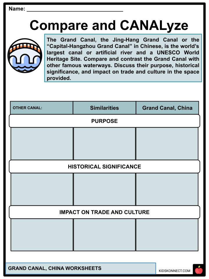
The Grand Canal, the Jing-Hang Grand Canal or the “Capital-Hangzhou Grand Canal” in Chinese, is the world’s longest canal or artificial river and a UNESCO World Heritage Site.
See the fact file below for more information on the Grand Canal, or you can download our 40-page Grand Canal worksheet pack to utilize within the classroom or home environment.
Key Facts & Information
EARLY PERIODS
- Fuchai, King of the State of Wu (in which the capital is today Suzhou), traveled north to fight the State of Qi in the late spring and autumn. He directed the construction of a canal for commerce purposes and a method of shipping adequate supplies north in case his soldiers were to battle the northern states of Song and Lu.
- Work on what became the Han Canal started in 486 BCE, from south of Yangzhou to north of Huai’an in Jiangsu, and within three years, it had connected the Yangtze with the Huai River by exploiting existing rivers, lakes, and marshes. Because the Hong Canal most likely preceded it, the Han Canal is recognized as the second-oldest segment of the later Grand Canal.
THE SUI DYNASTY
- The parts of the Grand Canal that exist today in Zhejiang and southern Jiangsu provinces were built due to the shift of China’s primary commercial and agricultural sector out of the Yellow River valley in the north and toward the south of the provinces during the Sui dynasty. Throughout its history, its primary function has been to convey grain to the capital.
- The construction of the Grand Canal by the Qin and Sui Dynasties, primarily the Sui, also eliminated the necessity for the army to become independent farmers when stationed at the northern frontier since food supplies could now be readily delivered from south to north across the pass.
- By 600, extensive silt had accumulated on the bottom of the Hong Canal, obstructing riverboats with draughts too deep for its waters. The Sui Dynasty’s top engineer, Yuwen Kai, proposed creating a new canal parallel to the present canal and diverging from it at Chenliu (Yanzhou).
- The new canal was to flow via Suzhou rather than Xuzhou, avoiding the Si River and instead linking directly with the Huai River slightly west of Lake Hongze. The first significant part of the Grand Canal, known as the Bian Qu, was finished in 605 with the work of 5 million people under the direction of Ma Shumou. From 604 to 609, the second Sui emperor finished the Grand Canal, first connecting Luoyang to Yangzhou, then extended it to Hangzhou (south) and Beijing (north). This extension enabled the southern region to supply grain to the northern province, notably troops stationed there.
- During 604 and 609, Emperor Yang of the Sui Dynasty authorized the construction of many canals in the shape of a “Y” from Hangzhou in the south to (modern) Beijing and the city’s region along the Yellow River valley. When the canal was finished, it linked the systems of the Huai River, Yangtze River, Qiantang River, Wei River, Yellow River, and Hai River.
- The Jiangnan River (the ‘South of the Yangtze’), named after its southern part, runs between Hangzhou and the Yangtze. The canal’s center sections extended from Yangzhou to Luoyang, the segment between the Yangtze and the Huai stretched to the Shenyang River, and the following part, known as the Tongji Channel, connected the Huai to the Yellow River.
- The Yongji Channel, named for the northernmost part, connects Beijing with Luoyang. This portion of the canal was used to transport armies to what is now the North Korean borderline area during the Goguryeo-Sui Wars (598-614). Emperor Yang led a 105-kilometer-long naval fleet of boats from the north to his southern metropolis, Yangzhou, following the canal’s completion in 609.
TANG TO YUAN DYNASTIES
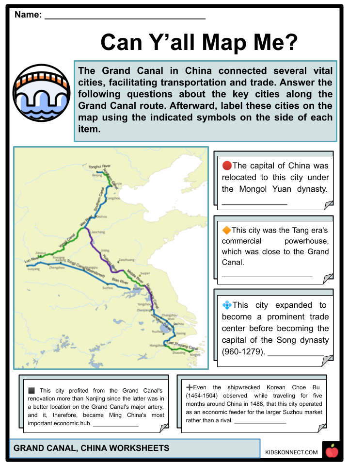
- While the Tang Dynasty (618-907) capital, Chang’an, was China’s most prosperous metropolis, the Tang era’s commercial powerhouse was Yangzhou, close to the Grand Canal. In addition to being the head office for the government salt monopoly and the empire’s central pre-modern industrial production hub, Yangzhou was also geographically halfway along the north-south trade axis. Hence, it became the principal center for southern products carried north.
- One of the most significant advantages of the Tang dynasty’s canal system—and following dynasties’ canal systems—was that it decreased the cost of conveying grain collected in taxes from the Yangtze River Delta to northern China.
- Minor improvements to the canal were made after the Sui period to reduce travel time, but there were no significant variations between the Sui Grand Canal and the Tang Grand Canal. Due to conflicts and repeated floods of the Yellow River during the An Shi Rebellion (755-763), the economic sector of northern China suffered greatly and never recovered. In 858, a disastrous flood along the Grand Canal swamped hundreds of hectares of farmland on the North China Plain, drowning tens of thousands of people. Such an undesirable circumstance may weaken a governing dynasty’s legitimacy by leading people to believe it had lost the Mandate of Heaven; this was a powerful cause for dynastic rulers to keep the canal system running smoothly and efficiently.
- Kaifeng expanded to become a prominent trade center before becoming the capital of the Song dynasty (960-1279). Although the Tang and Song dynasties’ international seaports—the most important of which were Guangzhou and Quanzhou, respectively—and marine overseas commerce provided tremendous riches to merchants, the Grand Canal within China drove the most economic activity and commercial success.
- During the Song and earlier dynasties, barge ships would regularly collide and wreck when passing through the twin slipways on the Shenyang Yundao portion of the Grand Canal, and they would be plundered of their grain by local bandits.
- The pound lock, a double-gate mechanism, was designed in 984 by Qiao Weiyue, an Assistant Commissioner of Transport for Huainan. This system allowed ships to wait in a gated zone while water was drained to safe levels; the Chinese also built roofed aircraft hangars over the space to give extra protection for the ships.
- The capital of China was relocated to Beijing under the Mongol Yuan dynasty (1271-1368), eliminating the necessity for the canal arm going west to Kaifeng or Luoyang. During the 1280s, a summit segment was excavated over the slopes of the Shandong mountain, decreasing the overall length by up to 700 km (430 mi), bringing the entire distance to around 1,800 km (1,100 km) and connecting Hangzhou and Beijing with a straight north-south canal for the first time. The canal, like the Song and Jin dynasties before it, fell into neglect and deterioration during the Yuan dynasty’s fall.
MING DYNASTY RESTORATION
- The Grand Canal was nearly fully restored between 1411 and 1415 during the reign of the Ming dynasty (1368-1644). A magistrate from Jining, Shandong, protested the current inefficient method of shipping 4,000,000 dan (428,000,000 liters) of grain per year via multiple rivers and canals in barge types that went from deep to superficial after the Huai River and then went back to deep barges once the grain transport reached the Yellow River.
- Chinese engineers constructed a dam to redirect the Wen River to the southwest, allowing 60% of its water to flow north into the Grand Canal and the remaining south. In Shandong, they created four enormous reservoirs to maintain water levels, allowing them to avoid pumping water from nearby sources and water tables. Between 1411 and 1415, 165,000 workmen dug the Shandong canal bed and erected additional channels, foundations, and canal locks.
- Suzhou profited from the Grand Canal’s renovation more than Nanjing since the latter was in a better location on the Grand Canal’s central artery, becoming Ming China’s most important economic hub. Hangzhou, the only prospective Jiangnan rival, was positioned 200 kilometers (120 miles) farther down the Grand Canal and away from the significant delta.
- Even the shipwrecked Korean historian Choe Bu (1454-1504) observed, while traveling for five months around China in 1488, that Hangzhou operated as an economic feeder for the larger Suzhou market rather than a rival. As a result, the Grand Canal was essential in determining the economic fortunes of cities along its course, including serving as the economic lifeline of indigenous trade inside China.
QING DYNASTY AND MODERN CHINA
- The Manchus invaded China in the mid-17th century after the Ming capital of Beijing had fallen into the hands of a rebel force and were let through the northern routes by the Chinese commander Wu Sangui. The Manchus created the Qing dynasty (1644-1912), and the Grand Canal was controlled and maintained in the same manner as before. The Yellow River overflowed and shifted the channel in 1855, interrupting the canal’s path in Shandong.
- A Chinese official predicted this in 1447 when he said that the flood-prone Yellow River made the Grand Canal look like a neck that might be easily choked (causing some authorities to propose that grain exports across the East China Sea be resumed). The canal’s dikes were opened in 1855 to flood the approaching troops of the Taiping Rebellion Northern Expedition.
- The canal languished for decades due to various factors, including the challenge of navigating the Yellow River, the growing development of an alternative sea route for grain ships, and the construction of the Tianjin-Pukou Railway and the Beijing-Hankou Railway. Many canal sections disappeared, and some converted to flat fields. The Grand Canal has yet to recover from this calamity fully. Following the establishment of the People’s Republic of China in 1949, the government ordered extensive rehabilitation work. The Grand Canal was crucial during the Great Leap Forward because it efficiently transported wheat.
- By the 1990s, the canal’s pollution had gotten so bad that boat and barge personnel could tell when they were getting close to Hangzhou by the stink of the black water. A $250 million restoration effort that began in 2001 has restored water quality to the point that it no longer stinks and can support particular fauna. The canal’s economic importance is anticipated to persist. Dredging projects in Shandong, Jiangsu, and Zhejiang Provinces were scheduled to enhance shipping capacity by 40% by 2012. The Grand Canal was designated a World Heritage Site on June 22, 2014, at the 2014 Conference on World Heritage.
HISTORICAL SECTIONS
- In addition to its current route, fourteen centuries of canal construction have left the Grand Canal with various historical parts. Some have vanished, some are just partially surviving, while others serve as the foundation for the contemporary canal. The following are the most essential, but they are not complete.
Jia Canal
- A man named Li Hualong built the Jia Canal in 12 BCE to overcome the problem of the Grand Canal needing to use 160 kilometers (100 mi) of the dangerous path of the Yellow River in Northern Jiangsu. It ran 140 kilometers (87 miles) from Xiazhen (modern Weishan) on the shore of Shandong’s Weishan Lake to Suqian in Jiangsu, named for the Jia River that it followed. The Jia Canal left just 100 kilometers (62 mi) of Yellow River transit on the Grand Canal from Suqian to Huai’an, which was eliminated by Jin Fu’s building of the Middle Canal in 1688.
Nanyang New Canal
- In 1566, the Nanyang New Canal was created to reduce flooding from the Yellow River at Yutai (now on the western side of Weishan Lake). It ran 75 kilometers (47 miles) from Nanyang (now Nanyang Town, in the center of Weishan Lake) to Liucheng (north of Xuzhou City, near current Gaolou Village, Weishan County, Shandong).
- The Grand Canal was successfully relocated from the shallow and flood-prone terrain west of Weishan Lake to a bit higher ground east of the lake. It was supplied by rivers flowing east to west from the Shandong massif’s boundaries.
Huitong Canal
- The Huitong Canal continued north of the Jizhou Canal’s upper section, fed mainly by the River Wen until it entered the Wei River near Linqing. In 1289, a geological examination preceded its one-year construction. The Huitong Canal, established by a Chinese engineer named Ma Zhizhen, passed through steeply sloping terrain, earning it the nickname chahe or zhahe, which translates as “the river of locks.” Due to the abundance of feeder springs, it became known as the quanhe, or “river of springs.”
Jizhou Canal
The Mongol Oqruqi built the first genuine peak section of the Grand Canal in 1238, linking Jining to the Huitong Canal’s southern terminus. It climbed 42 meters (138 feet) above the Yangtze, but ecological and technological concerns caused chronic water shortages until Song Li of the Ming re-engineered it in 1411. Song Li’s repairs, driven by a local named Bai Ying, comprised blocking the rivers Wen and Guang and building lateral canals to produce reservoir lakes at the top of a little settlement called Nan Wang.
Duke Huan’s Conduit
- Commander Huan Wen of the Eastern Jin Dynasty joined the minor canals of the Huai and Yellow in 369 CE. He did this by crossing a low watershed of the Shandong massif and joining two of these rivers’ streams, the Si and Ji, near their confluence. Huan Wen’s rudimentary mountaintop canal inspired Jizhou Canal engineers.
Yilou Canal
- The Shanyang Canal was initially linked to the Yangtze at Yangzhou. As the Yangtze north coast silted up, forming the sandbank island of Guazhou, boats sailing between it and the Jiangnan Canal had to circumnavigate the island’s eastern side. Following a particularly challenging Yangtze crossing from Zhenjiang, the city prefect saw that a canal dug directly through Guazhou would shorten travel time and make the voyage safer.
MODERN COURSES
- The Grand Canal nominally runs 1,794 kilometers (1,115 miles) from Beijing and Hangzhou, but only the section between Hangzhou and Liangshan County is presently navigable. Its present path is divided into seven sections. From south to north, the Inner Canal, Middle Canal, South Canal, North Canal, Lu Canal, Li Cana, Jiangnan Canal, and Tonghui River are listed.
Man-Made Lake Lianhu
- Training Lake “Lianhu” water irrigated a segment of the Grand Canal near Jiangnan. Because the canal was artificial, there was insufficient naturally running water to keep it at the proper depth for boats to navigate. As a result, an artificial lake was constructed to supply water to the Jiangnan portion of the Grand Canal. The government protected it against restoration, and any use of lake water that was not adequately taxed was deemed criminal. Lake Lianhu was intended to be safeguarded from commercial use, but as governments changed, it was reclaimed several times and grew increasingly shallow.
- The government transformed the lake to create more productive agriculture, leading to reclamations and irrigation for agriculture using the lake. As a result, Lake Lianhu could not efficiently supply water to the Grand Canal. The lake’s depth disappeared due to reclamation, and the maintenance costs were prohibitively expensive for it to be utilized.
- Even though it was an artificial lake, it was a magnificent sight. Its beauty moved numerous people, and innumerable poems were written about it. The lake’s recreational usage has expanded in popularity in recent years, which may help its rehabilitation.
Jiangnan Canal
- The canal’s southernmost segment stretches from Hangzhou, Zhejiang, where it links with the Qiantang River, to Zhenjiang, Jiangsu, where it joins the Yangtze. After leaving Hangzhou and going north toward Beijing, the canal follows the eastern shore of Lake Tai, passing through Jiaxing, Suzhou, Wuxi, and Changzhou until arriving at Zhenjiang.
- The Jiangnan (or ‘South of the Yangtze’) Canal is widely used by barge traffic, transporting coal, containers, and building supplies to the thriving delta.
- It is usually at least 100 meters wide in busy city areas and sometimes twice or three times broader in the surrounding countryside. Broad bypass canals have been built around major cities in recent years to alleviate “traffic jams.” The Suzhou segment of the Jiangnan Canal runs through the city’s western outskirts. It has 10 city gates, over 20 stone bridges of traditional style, and well-preserved medieval sections, as well as temples and pavilions.
Inner Canal
- The Inner Canal binds the Yangtze and Huai rivers in central Jiangsu, passing via Shaobo, Gaoyou, and Hongze lakes. This segment links the cities of Huai’an and Yangzhou.
- The topography west of the canal is higher than the canal bed, whereas the area east of the channel is lower. The Shanghe area west of the canal has had regular flooding. In contrast, the Xiahe region to the east has experienced less frequent but substantially more damaging floods caused by Grand Canal embankment failure. Thanks to recent efforts, floodwaters from Shanghe may now be safely directed out to sea. The Inner Canal, like the Jiangnan Canal, is frequently used by barge traffic transporting coal, building materials, and increasingly shipping containers across Jiangsu Province.
Middle Canal
- This section of the ‘Middle Canal’ connects Huai’an to Weishan Lake, passing via Luoma Lake and adopting several paths due to the effect of centuries of Yellow River floods. Following Pizhou, a northerly road joins Weishan Lake at Hanzhuang on its way to Nanyang and Jining (this route is the remnants of the 1566 New Nanyang Canal). A trail leading south from Xuzhou leads to Weishan Lake in Peixian. This latter route is less prevalent these days. Barge traffic uses the canal to deliver coal and building materials throughout northern Jiangsu Province.
Lu Canal
- Both streams reach Shandong province at Weishan Lake. The canal from here to Linqing is called the Lu or ‘Shandong’ Canal. It passes through a succession of lakes—Zhaoyang, Dushan, and Nanyang—that form a seemingly continuous body of water. Currently, water diversions cause the lakes to be primarily dry ground. Jining lies north of the northernmost Nanyang Lake. The maximum height of the canal (38.5 m or 126 ft above sea level) is reached near the town of Nanwang, about 30 km (19 km) north of Jining.
- A new canal was created to the south of the old peak portion in the 1950s. The old peak portion is now dry, and the rebuilt canal has insufficient water to be passable. The canal reaches the Yellow River around 50 kilometers (31 miles) farther north, near Dongping Lake.
- It is no longer connected to the river because it is now waterless. It returns to Liaocheng City on the north bank, where it flows sporadically via a restored stone channel until it reaches Linqing on the Shandong-Hebei border. Liangshan County serves as the canal’s northern terminal for barge traffic.
Southern Canal
- The fifth stretch of the canal runs for 524 kilometers (326 miles) along the canalized Wei River from Linqing to Tianjin. Despite being one of the northernmost parts, its name comes from its location in Tianjin.
- The Wei River is highly polluted at this point, and it is too low to be navigable due to drought and industrial water extraction.
- The canal, currently in Hebei province, runs through Dezhou and Cangzhou. Although the canal seems to observers to be a deep channel in these city centers, weirs preserve its depth, and the canal is nearly dry as it runs through the surrounding farmland. The canal connects the Hai River in the middle of Tianjin City before curving northwest at its terminus.
Northern Canal and Tonghui River
- The canal begins in Tianjin and travels northwest, briefly following the path of the Yongding, a tributary of the Hai River, before splitting off toward Tongzhou on the outskirts of Beijing. The contemporary canal ends here, and a Grand Canal Cultural Park has been established. During the Yuan period, a new channel on the Tonghui River linked Tongzhou to the Houhai or “rear sea” port in downtown Beijing.
- However, between the Ming and Qing dynasties, the water level in the Tonghui River decreased, rendering ships unable to travel from Tongzhou to Beijing. Tongzhou was subsequently established as the canal’s northern shipping terminus. The cargo was unloaded at Tongzhou and transported by land to Beijing. The Tonghui River remains a vast, concrete-lined storm drain and canal feeding Beijing’s outskirts.
Eastern Zhejiang Canal
- Zhejiang is home to the Eastern Zhejiang Canal. It runs east through Cao’e River and Shaoxing City to the Yong River delta in Ningbo City, beginning at Xixing Street, Binjiang District, Hangzhou City. The canal spans 239 kilometers (149 miles). Early canal building occurred in the Spring and Autumn periods (about 771 to 476 BC) in the Shanyin ancient canal in Shaoxing City. An official named He Xun oversaw the building of the Xixing Canal in the third century AD, completing the Eastern Zhejiang Canal.
- The capital was founded in Linan during the Southern Song dynasty (1127-1279), indicating that the Eastern Zhejiang Canal became a significant shipping canal. The Eastern Zhejiang Canal lost its advantages but remained passable from the Yuan Dynasty (1271-1368) through the Qing Dynasty (1644-1912). The canal has increasingly been superseded in recent years due to modern transportation sources. The canal’s repair began in 2002, and by 2007, it was partially navigable. The renovation project was completed in 2009. However, the Ningbo portion was not passable until 2013.
- In May 2013, the Eastern Zhejiang Canal became included in the Grand Canal and designated in the eighth group of Major Historical and Cultural Sites Protected at the National Level. The Eastern Zhejiang Canal was nominated for UNESCO World Heritage status in November 2008 as an extension of the Beijing-Hangzhou Grand Canal and a link between the Grand Canal and the Maritime Silk Road. The Eastern Zhejiang Canal was designated a World Heritage property in 2014, together with the Beijing-Hangzhou Grand Canal and the Sui & Tang Grand Canal.
USES
Transportation
- The Grand Canal was the main artery uniting northern and southern China from the Tang through the Qing dynasties, and it was vital for grain transit to Beijing. Although primarily used to move grain, it also carried other items, and the canal corridor expanded to become an important commercial route. According to records, around 8,000 boats pass through each year at its height, with four to six million dan (240,000-360,000 metric tons) of grain transported.
- Because of the convenience of transportation, monarchs might also lead inspection trips to southern China. The Kangxi and Qianlong emperors conducted twelve expeditions to the south during the Qing dynasty, except one that concluded at Hangzhou.
- The Grand Canal also enabled cultural and political exchange between China’s north and south. The canal also wowed some of China’s early European visitors. Italian explorer and merchant Marco Polo described the Grand Canal’s arches, as well as the stores and flourishing trade of its cities in the 13th century.
- Around the end of the 16th century, missionary Matteo Ricci journeyed down the canal from Nanjing to Beijing.
- Since the establishment of the People’s Republic of China in 1949, the canal has been chiefly used to transport large quantities of bulk items like bricks, gravel, sand, diesel, and coal. The Jianbi ship locks on the Yangtze, handling around 75,000,000 tons annually, while the Li Canal is expected to take 100,000,000 tons during the following few years. When it was initially built, the canal was an essential mode of transit connecting northern and southern China.
- Passenger transport on the canal became much less prevalent after the arrival of expressways, trains, and high-speed railways in modern China. Ships may currently only go up to Jining. Due to silt accumulation from the Yellow River and a shortage of water supplies, the portion from Jining to Beijing is not transportable. There are intentions to restore transit to Tai’an.
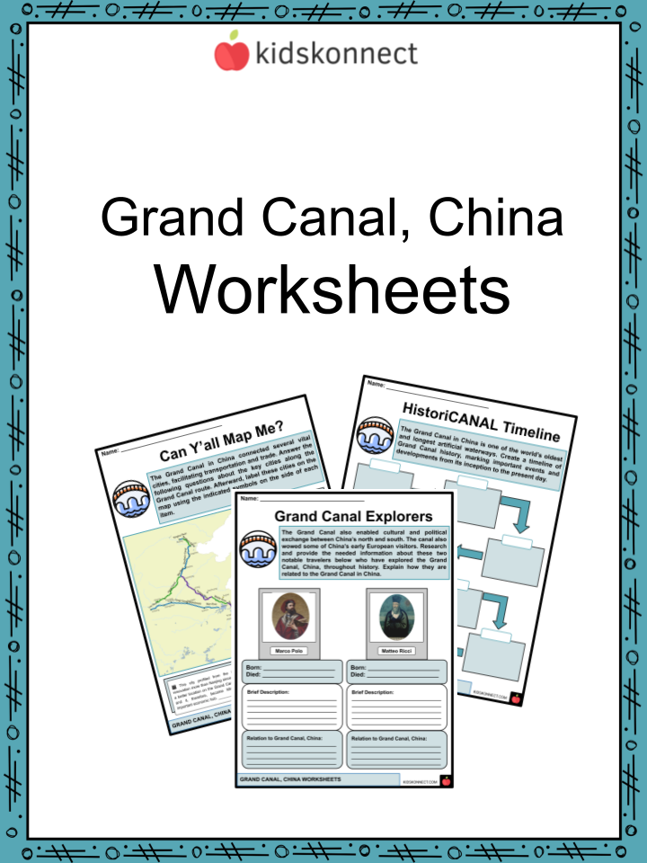
Grand Canal, China Worksheets
This fantastic bundle includes everything you need to know about the Grand Canal, China across 40 in-depth pages. These ready-to-use worksheets are perfect for teaching kids about the Grand Canal, China. The Grand Canal, the Jing-Hang Grand Canal or the “Capital-Hangzhou Grand Canal” in Chinese, is the world’s longest canal or artificial river and a UNESCO World Heritage Site.

Complete List of Included Worksheets
Below is a list of all the worksheets included in this document.
- Grand Canal, China Facts
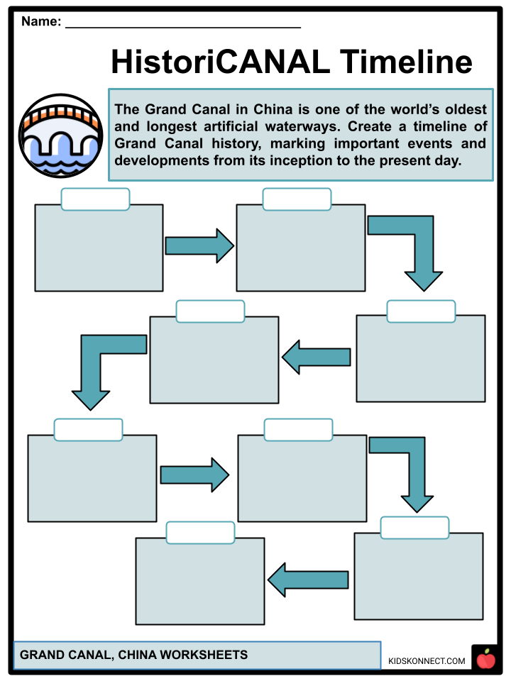
- HistoriCANAL Timeline
- Can Y’all Map Me?
- Compare and CANALyze
- Engineering Marvels
- Grand Canal Explorers
- Grand Canal Time Capsule
- HistoriCANAL Sections
- Grand Canal Search
- Poem CANALysis
- SignifiCANALs
Frequently Asked Questions
What is the Grand Canal of China?
The Grand Canal, known in Chinese as the “京杭大运河” (Jīng-Háng Dà Yùnhé), is a vast artificial waterway system in China. It is one of the world’s oldest and longest man-made canals, running over 1,100 miles (1,800 kilometers) from Beijing in the north to Hangzhou in the south.
When was the Grand Canal of China first built?
The construction of the Grand Canal began during the 5th century BCE in various phases, but it was during the Sui Dynasty (581–618 CE) that the major efforts to link existing waterways into a single unified canal system were undertaken.
What was the purpose of the Grand Canal?
The Grand Canal was primarily constructed for transportation and trade purposes. It facilitated the movement of goods, including grain, rice, silk, and other commodities, between the northern and southern regions of China, promoting economic and cultural exchange.
Is the Grand Canal still in use today?
Yes, parts of the Grand Canal are still in use for transportation and irrigation. While it may not play as central a role in trade as it once did, it remains an important waterway for local transport and agriculture. Some sections are also popular for tourism and scenic boat cruises.
Is the Grand Canal considered a UNESCO World Heritage Site?
Yes, in 2014, the Grand Canal was designated as a UNESCO World Heritage Site. This recognition acknowledges its historical significance and its role in shaping China’s economic and cultural development over the centuries.
Link/cite this page
If you reference any of the content on this page on your own website, please use the code below to cite this page as the original source.
Link will appear as Grand Canal, China Facts & Worksheets: https://kidskonnect.com - KidsKonnect, October 4, 2023
Use With Any Curriculum
These worksheets have been specifically designed for use with any international curriculum. You can use these worksheets as-is, or edit them using Google Slides to make them more specific to your own student ability levels and curriculum standards.