Premium
 Download
Edit
Download
Edit
Download the Euphrates River Facts & Worksheets
Click the button below to get instant access to these worksheets for use in the classroom or at a home.
Download This Worksheet
This download is exclusively for KidsKonnect Premium members!
To download this worksheet, click the button below to signup (it only takes a minute) and you'll be brought right back to this page to start the download!
Sign Me Up
Edit This Worksheet
Editing resources is available exclusively for KidsKonnect Premium members.
To edit this worksheet, click the button below to signup (it only takes a minute) and you'll be brought right back to this page to start editing!
Sign Up
Not ready to purchase a subscription? Click to download the free sample version Download sample
Download This Sample
This sample is exclusively for KidsKonnect members!
To download this worksheet, click the button below to signup for free (it only takes a minute) and you'll be brought right back to this page to start the download!
Sign Me Up
Table of Contents
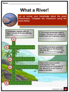
The longest and most important river in terms of history in Western Asia is the Euphrates, and it is one of Mesopotamia’s two defining rivers and the Tigris. The Euphrates, which has its source in Turkey, joins the Tigris near Shatt al-Arab and empties it into the Persian Gulf.
See the fact file below for more information on the Euphrates River, or alternatively, you can download our 24-page Euphrates River worksheet pack to utilize within the classroom or home environment.
Key Facts & Information
Course
- The longest river in Western Asia is the Euphrates. Ten kilometers (6.2 miles) upstream of the town of Keban in the southeastern, it arises from the confluence of the Kara Su or Euphrates (450 kilometers [280 mi]) and the Murat Su or Eastern Euphrates (650 kilometers [400 mi]).
- At 3,290 meters (10,790 feet) and 3,520 meters (11,550 feet) amsl, respectively, the Kara Su and Murat Su climb northwest. The two rivers, which have now joined to form the Euphrates, have dipped to a height of 693 meters (2,274 feet) amsl where the Keban Dam is located.
- The Euphrates’ gradient sharply declines when it enters the plains of Upper Mesopotamia. In contrast, it dips 163 meters (535 feet) within Syria; it only drops 55 meters across its last section between Hit and the Shatt al-Arab. The river falls 368 meters (1,207 feet) from Keban to the Syrian-Turkish border (180 ft.)
History
Ancient History
- Southern Mesopotamia increased the number and size of communities during the Jemdet Nasr (3600-3100 BCE) and Early Dynastic eras (3100-2350 BCE), which suggests significant population expansion.
- Upper Mesopotamia, Subartu, and Assyria also had comparable growth, but on a lower scale than in Lower Mesopotamia and only beginning in the middle of the third millennium. At this time, places like Ebla, Mari, and Tell Leilan rose to prominence for the first time.
- Control of the greater Euphrates basin shifted over the following centuries from the Neo-Assyrian Empire (which fell between 612 and 599 BCE) to the Achaemenid Empire, the Median Empire (612-546 BCE), the equally short-lived Neo-Babylonian Empire (612-539 BCE), and finally the short-lived Neo-Babylonian Empire (612-539 BCE) (539-333 BCE.)
- The northern border of the river was shared by Greater Armenia (331 BC-428 CE) and Lesser Armenia (the latter became a Roman province in the 1st century BCE.)
Modern Era
- As the Ottoman Empire was divided after World War I, it redefined the borders in Southwest Asia in the Treaty of Lausanne (1923).
- The treaty’s clause 109 required the three Euphrates riparian states—at the time, Turkey, France for its mandate in Syria, and the United Kingdom for its rule in Iraq—to come to an understanding about the use of the river’s water and the development of any hydraulic facilities.
- Much of the Euphrates was under the control of the Islamic State during the Syrian Civil War and the Iraqi Civil War from 2014 until 2017, when the terrorist organization started to lose territory and was ultimately defeated territorially in Syria at the Battle of Baghouz and in Iraq at the Western Iraq offensive, respectively.
Religion
Islam
- Islam refers to a hadith that states there would be many casualties in wars over the discovery of a gold mountain beneath the Euphrates river before the world’s end. It is seen as one of the upcoming minor signs of the imminent Day of Judgment.
Christianity
- The Euphrates River is only mentioned in the final book of the New Testament, the Book of Revelation, in the Christian Bible. Author John the Apostle lists the disappearance of the Euphrates River as one of the events that foretold the Second Coming of Jesus Christ.
Discharge
- The majority of the water in the Euphrates comes from snowmelt and rainfall, with peak flows occurring in April and May. According to one estimate, the Euphrates releases 36% of its yearly total during these two months—or perhaps 60–70%—while summer and fall have minimal runoff rates.
- Since building the first dams in the 1970s, the Euphrates discharge regime has drastically transformed. The obstacles that led to the numerous barriers to the Euphrates and the increasing water demand for agriculture are evident in data on Euphrates discharge gathered after 1990.
- By 1990, the average Ht discharge decreased to 356 cubic meters per second (12,600 cu ft) (11.2 cubic kilometers (2.7 cu mi) per year), and the seasonal fluctuation also reduced.
- In contrast to the peak volume recorded at Ht after 1990, which was just 2,514, the pre-1990 peak volume at Ht was 7,510 cubic meters (265,000 cu ft) per second. Before 1990, the minimum volume at Ht increased from 55 cubic meters (1,900 cu ft) per second to 58 cubic meters (2,000 cu ft).
Tributaries
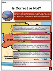
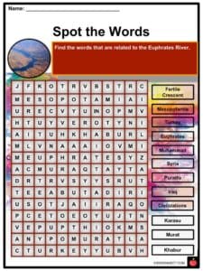
- The Sajur, Balikh, and Khabur rivers in Syria are three of the rivers that feed water into the Euphrates. These rivers flow into the Euphrates rather seldom, rising in the Taurus Mountains’ foothills near the Syrian-Turkish border.
- The smallest of these tributaries, the Sajur, rises from two streams close to Gaziantep, drains the area surrounding Manbij, and then empties into the reservoir of the Tishrin Dam.
- Most of the water for the Balikh comes from a karstic spring close to ‘Ayn al-‘Arus, and it runs south until it joins the Euphrates at Raqqa. Regarding length, drainage basin, and discharge, the Khabur is the greatest of these three.
Drainage Basin
- The Kara Su and Murat River drainage basins total 22,000 square kilometers (8,500 square miles) and 40,000 square kilometers (15,000 square miles), respectively.
- The Euphrates drainage basin size has been estimated to be anywhere from 233,000 square kilometers (90,000 square miles) to 766,000 square kilometers (296,000 sq mi.)
- The significant portions of the Euphrates basin are in Turkey, Syria, and Iraq. Daoudy and Frenken estimate that Turkey has a 28 percent stake, Syria has a 17 percent share, and Iraq has a 40 percent part.
- According to some accounts, Saudi Arabia makes up 15% of the drainage basin, whereas Kuwait‘s boundaries only cover a minor portion.
- Last but not least, according to some sources, Jordan is part of the Euphrates drainage basin since a small portion of the eastern desert (220 square kilometers/85 square miles) flows eastward rather than westward.
Natural History
- There are several unique vegetation zones where the Euphrates runs. Patches of ancient flora still exist in the Euphrates basin despite centuries of human habitation severely ruining the terrain.
- The Cyprinidae family, which comprises 34 of the total 52 fish species in the Tigris-Euphrates basin, is the most numerous. The mangar, a Cyprinid, earned the moniker “Tigris Salmon” from the British due to its favorable recreational fishing characteristics.
- The wolf, golden jackal, red fox, leopard, and lion are some examples of predatory animals. In the highlands of southeast Turkey, the Syrian brown bear makes its home.
- The bone assemblage discovered at the Syrian archaeological site of Tell Abu Hureyra attests to the existence of Eurasian beavers. Yet, there are no known instances of beavers in the past.
River
- The Tigris-Euphrates river system’s first contemporary water diversion device was constructed on the Iraqi Euphrates in 1913, following the designs of British civil engineer William Willcocks.
- A complex network of canals connecting the Euphrates with Lake Habbaniyah, Lake Tharthar, and the Abu Dibbis reservoir, which may also utilize to store surplus floodwater, has also been built by Iraq in addition to barrages and dams.
- The Shatt al-Hayy joins the substantial Euphrates and Tigris. The Main Outfall Drain, built between 1953 and 1992, is the most extensive canal in this network. This 585-kilometer (351 mi) long canal is designed to drain the region south of Baghdad between the Tigris and the Euphrates to stop soil salinization, and it makes large freight barges navigable.
Environmental and Social Effects
- The development of dams and irrigation systems on the Euphrates has significantly changed each riparian nation’s nature and civilization.
- According to a poll, most displaced persons were dissatisfied with their new circumstances, and their compensation should be considered inadequate.
- Lake Assad’s inundation brought about the forced relocation to establish an “Arab belt” along the borders with Turkey and Iraq; 4,000 people were relocated to other areas of northern Syria as part of a now-abandoned scheme.
- The multiple dams and irrigation projects have had significant environmental repercussions in addition to changing the river’s flow schedule. Large-surface reservoir construction has increased evaporation and decreased the overall amount of water available for human consumption in nations with high average temperatures.
- Due to the lake’s recent drying up, portions of the formerly-flooded area are now once again accessible, opening up fresh study opportunities for archaeologists as well as prospects for looting, which has been prevalent throughout Iraq since the 2003 war.
Economy
- The Euphrates has been essential to those who have lived along its path throughout history.
- More people than ever before rely on the river for necessities like energy and clean water because of the development of massive hydropower plants, irrigation systems, and pipelines that can transport water over great distances.
- Baghdad receives electricity from the Haditha Dam in Iraq via a recently repaired power cable.
Euphrates River Worksheets
This is a fantastic bundle which includes everything you need to know about Euphrates River across 24 in-depth pages. These are ready-to-use Euphrates River worksheets that are perfect for teaching students about the Euphrates River, which is historically known as the longest and one of the most important rivers in Western Asia.

Complete List of Included Worksheets
- Euphrates River Facts
- Is Correct or Not?
- What a River!
- Time to wear the Thinking Hats
- Spot the Words
- Knowing Euphrates
- Life in the Euphrates
- Let’s Clean Up
- All about Agreements
- Article Analysis
- Team Up to Clean Up
Frequently Asked Questions
What is the Euphrates River?
The longest and most important river in terms of history in Western Asia is the Euphrates, and it is one of Mesopotamia’s two defining rivers and the Tigris. The Euphrates, which has its source in Turkey, joins the Tigris near the Shatt al-Arab and empties into the Persian Gulf.
Where does the majority of the water in the Euphrates come from?
The majority of the water in the Euphrates comes from snowmelt and rainfall, with peak flows occurring in April and May. According to one estimate, the Euphrates releases 36% of its yearly total during these two months—or perhaps 60–70%—while summer and fall have minimal runoff rates.
What are the tributaries of the Euphrates river?
The Sajur, Balikh, and Khabur rivers in Syria are three of the rivers that feed water into the Euphrates. These rivers flow into the Euphrates rather seldom, rising in the Taurus Mountains’ foothills near the Syrian-Turkish border. The smallest of these tributaries, the Sajur, rises from two streams close to Gaziantep, drains the area surrounding Manbij, and then empties into the reservoir of the Tishrin Dam.
Where are the significant portions of the Euphrates basin located?
The significant portions of the Euphrates basin are in Turkey, Syria, and Iraq. Daoudy and Frenken estimate that Turkey has a 28 percent stake, Syria has a 17 percent share, and Iraq has a 40 percent part.
What environmental and social effects are the Euphrates river facing now?
The multiple dams and irrigation projects have had significant environmental repercussions in addition to changing the river’s flow schedule. Large-surface reservoir construction has increased evaporation and decreased the overall amount of water available for human consumption in nations with high average temperatures.
Link/cite this page
If you reference any of the content on this page on your own website, please use the code below to cite this page as the original source.
Link will appear as Euphrates River Facts & Worksheets: https://kidskonnect.com - KidsKonnect, December 11, 2018
Use With Any Curriculum
These worksheets have been specifically designed for use with any international curriculum. You can use these worksheets as-is, or edit them using Google Slides to make them more specific to your own student ability levels and curriculum standards.